- Name the most large lakes Russia.
- Which lakes in our country have basins of the same origin as the largest lakes in Africa; North America?
- Remember the main reasons for the formation of swamps.
- How is groundwater formed?
Lakes... There are a little less than three million lakes in our country. Among the lakes of Russia, the largest sea-lake in the world is the Caspian and the deepest (1637 m) freshwater lake Baikal.
Table 4. The largest lakes in Russia

The distribution of lakes throughout the country is very uneven and depends on many reasons: geological structure and terrain, climatic conditions, occurrence features groundwater.
By climate maps determine in which part of our country the conditions for the existence of lakes are the most favorable.
The number of lakes decreases significantly to the south due to the increasing aridity of the climate.
The origin of the lake basins is diverse (Table 5).
Lakes are sources of fresh water, food products, raw materials (for example, salt in lakes Elton and Baskunchak), flow regulators, navigable routes, wonderful places of rest.
Unlike rivers, lakes are reservoirs with calm water, but they also actively influence other components of nature. Lakes change the relief: they create the bottom and shores, cliffs and terraces, overwhelm their basins with peat, silt, salt, turning them into swampy plains, salt marshes and even salt deposits. Lakes influence the climate: in summer they moderate the heat, in winter they soften the cold; moisten the windward shores with moisture evaporating from their surface.
Table 5. Origin of lake basins in our country

Think, in which areas of our country, instead of lakes, swampy plains can form; salt marshes.
Reservoirs, which are created on rivers by the construction of dams, have become a new type of lakes. But in addition to the benefits, reservoirs are capable of negatively affecting nature: destroying banks, raising flooded peat bogs from the bottom, cutting roads, flooding and flooding forests and agricultural land.
Swamps... The area of bogs in Russia is about 2 million km2, that is, over 10% of the entire territory.
Reasons for the occurrence of swamps: waterlogging of the soil with a large amount of precipitation, low evaporation and slow runoff. The evolution of small lakes also ends with the formation of bogs. The Northwest of the Russian Plain (up to 20-30%), Vasyugane in the West Siberian Plain (up to 70%), and the Amur basin (10-12%) are heavily bogged.
Remember how swamps are depicted on the map. Find the main swamp areas.
Bogs are an important source of food for rivers and lakes; a lot of useful berries: cranberries, cloudberries. Therefore, the conservation of wetlands is important for the protection and rational use the riches of nature.
Diverse and practical use swamps. About 80% of the country's peat reserves are concentrated in the swamps of the forest zone, which is used for thermal power plants and as a raw material for the chemical industry.
The groundwater although hidden from view, their role is great both in nature and in human life. These waters make their way at the bottom of the rivers with cold springs, come to the surface as ice springs. Extracted from wells or wells, these waters are used for domestic needs, irrigation of fields, watering of pastures.
Groundwater has different origins: some of them were formed as a result of the penetration of melt and rainwater to the first water-resistant horizon (that is, to a depth of 1.5-2 m - this is the so-called top water); others occupy deeper cavities in the ground.

Rice. 49. Transition of surface runoff into underground
Groundwater is fresh and mineral, containing quite large quantities of soluble salts and gases. Mineral waters are used in medicinal purposes... In different regions of the country - in Kamchatka, the Caucasus and elsewhere - reserves of thermal groundwater with temperatures ranging from 30 to 300 ° C have been identified.
Groundwater reserves in our country are estimated in many trillion cubic meters, of which 350 billion are considered suitable for use. However, only a small fraction of these reserves is still used - about 5%. But even such reserves are not unlimited. They, no less than ground waters, need protection, careful use, protection from pollution.
Glaciers currently occupy about 11% of the land; underground ice ( permafrost) is distributed over 14% of the Earth's land mass. In Russia, permafrost occupies 11.1 million km 2, that is, more than half of the entire territory.
Glaciers have a noticeable impact on nature: they are stores of moisture, they own important role in the feeding of rivers, they noticeably change the relief. Large covers land ice, similar to the Antarctic and Greenlandic, we do not have, but smaller ice sheets ("island" caps) are found on the Arctic islands. Mountain glaciers are common in the Caucasus, Northern Urals, in Altai, in Eastern Siberia, Sayan, in Transbaikalia and Kamchatka. Their total area about 3 thousand km 2.
In the highlands there is the so-called snow border, above which the snow falling during the cold season does not have time to melt and persists until next winter and then turns to ice.
V southern mountains the snow border lies higher than in the northern ones, and in the Arctic it goes down to sea level. Its height depends on the severity and humidity of the climate. On the well-moistened slopes of the Western Caucasus, this boundary can be traced at altitudes of 2700-2800 m, and on the drier slopes of the Eastern Caucasus - at altitudes of 3000-3200 m. In the Caucasus, there are up to 1400 glaciers; in Altai - 754, in the mountains of Eastern Siberia - 200 glaciers.
Permafrost- these are strata of rocks that contain ice that does not thaw for a long time, usually tens or many hundreds of years. Permafrost occupies the coast of the Northern Arctic Ocean in the European part of Russia, including the entire Kola Peninsula; Siberia is practically all (except for the south Western Siberia and Far Eastern Primorye) lies within its boundaries. Thus, more than 60% of the area of Russia is, to one degree or another, occupied by permafrost. In areas with the most severe climate - at the mouth of the Vilyui, in Oymyakon, where the sum of the average daily negative temperatures reaches 6000-7000 ° C, - the thickness of the permafrost layer is on average 600-800 m, and in some places it reaches 1500 m.
Permafrost has a significant impact on nature, as well as on human life and activities.

Rice. 50. State of permafrost during the year
Permafrost is a "refrigerator" for soil and surface air; it limits the depth of root penetration into the ground and their water supply. Waters accumulating on the permafrost swamp the area, leading to the formation of subsidence, flooding and swelling of the surface. Permafrost complicates the construction of roads, buildings, and mining. Our country has accumulated extensive experience in construction and economic activity in permafrost conditions. It was used in the construction of new cities - Norilsk, Mirny, in the construction of the BAM.
Questions and tasks
- What types of lake basins are there in our country? Is there a pattern in their placement?
- Think about what contributes to the formation of swamps; where there are especially many large swamps in our country. What is the role of swamps in nature?
- How important is groundwater for human life?
- In what areas are glaciers concentrated? Why?
- What are the reasons for the formation of permafrost. How does it affect nature, life and human activity?
On land there are five types of water accumulations : 1) groundwater, 2) rivers, 3) lakes, 4) glaciers, 5) swamps... Water is also present in the soil.
1. Groundwater
These are land waters located in the upper part of the earth's crust (to a depth of 12-16 km). Formed mainly by seepage atmospheric precipitation and the accumulation of water in the pores, cracks and voids of rocks. In relation to water, a distinction is made between permeable (sand, gravel), waterproof (clay, permafrost) and soluble (limestone, salt) breed.
According to the conditions of occurrence, there are soil (lie directly at the surface of the earth, in the soil), soils e (lie on the first waterproof layer) and interstratal (enclosed between two waterproof layers) of water. Interstratal waters are fed in areas where there is no upper water-resistant layer; can be pressurized, or artesian (if they fill the entire aquifer), and non-pressurized. Natural discharges of groundwater to the surface - sources , can be cold (up to +20 ° С), warm (+ 20-37 ° С) and hot (from +37 ° С).

2. Rivers
River- natural water stream, flowing in the same place continuously or intermittently.
! Read more about rivers in the synopsis.
3. Lakes
Lake- a closed natural depression on land, filled with water. It consists of a basin and a body of water. It is customary to classify lakes according to four criteria: the origin of the lake basins; the origin of the water mass; water regime; salinity. By origin, the lakes are divided into eight main groups.
- Tectonic lake basins are formed as a result of the formation of cracks, faults and subsidence of the earth's crust. They differ great depth and steep slopes (Baikal, Great North American and African lakes, Winnipeg, Big Slave, Dead Sea, Chad, Eyre, Titicaca, etc.).
- Volcanic, which are formed in craters of volcanoes or in depressions of lava fields (Kuril and Kronotskoe in Kamchatka, many lakes of Java and New Zealand).
- Glacial lake basins are formed in connection with the activity of glaciers (lakes in Finland, Karelia, the Alps, the Urals, the Caucasus, etc.).
- Karst lakes, the basins of which arose as a result of sinkholes, soil subsidence and erosion of rocks. Dissolution of these rocks with water leads to the formation of deep, but insignificant lake basins.
- Zaprudnye lakes arise as a result of blocking the river bed with rock blocks during rock falls in the mountains (Sevan, Tana, many lakes of the Alps, Himalayas and other mountainous countries).
- Estuary lakes are widespread on the shores of the seas - these are coastal areas of the sea, isolated from it by means of coastal spits.
- Oxbow lakes are lakes that have arisen in old riverbeds.
- Residual lakes appeared on the site of the former seas.
The lakes are fed by atmospheric precipitation, groundwater and surface waters flowing into them.
By water regime u distinguish sewage and drainless lakes. The river (rivers) - Baikal, Onega, Ontario, Victoria, etc. flows out of the waste lakes. Not a single river flows out of the drainless lakes - the Caspian, Dead, Chad and others. The drainless lakes, as a rule, are more mineralized. Depending on the degree of salinity, the lake water is fresh and salty.
By origin the water mass of the lake are two types :
- lakes, the water mass of which is of atmospheric origin (such lakes prevail in number);
- relict, or residual, - were once part of the World Ocean ( Caspian lake and etc.)
The distribution of lakes depends on the climate, and therefore the geographical distribution of the lakes is to a certain extent zonal. Lakes have great importance : affect the climate of the adjacent territory (humidity and thermal conditions), regulate the flow of rivers flowing from them. Economic value lakes: used as communication routes (less than rivers), for fishing and recreation, water supply. Salts and medicinal mud are extracted from the bottom of the lakes.

4. Swamps
Swamps- excessively humid land areas, covered with moisture-loving vegetation and having a peat layer of at least 0.3 m. Water in swamps is in a bound state. Swamps are formed as a result of overgrowth of lakes and waterlogging of the land.
Lowland swamps feed on soil or river waters, relatively rich in salts. Consequently, vegetation settles there, quite demanding food substances(sedge, horsetail, reed, green moss, birch, alder).
Upland swamps feed directly atmospheric precipitation... They are located on watersheds. Vegetation is characterized by limited species composition, because there is not enough mineral salts (wild rosemary, cranberry, blueberry, sphagnum mosses, pine). Transitional marshes occupy an intermediate position. Lowland and raised bogs are two stages in the natural development of bogs. Lowland swamp through an intermediate stage transitional swamp gradually turns into a horse.
The main cause of education huge swamps are characterized by excessive humidity of the climate, combined with high level groundwater due to the close occurrence to the surface of water-resistant rocks and flat relief.
The distribution of bogs also depends on the climate, which means that it is also zonal to a certain extent. Most of the swamps in the forest zone temperate zone and in the tundra zone. A large number of precipitation, low evaporation and water permeability of soils, flatness, weak dissection of interfluves contribute to waterlogging .

5. Glaciers
Glaciers– ice-converted land water of atmospheric origin. Glaciers are constantly moving due to their plasticity. Under the influence of gravity, the speed of their movement reaches several hundred meters per year. Movement slows down or accelerates depending on the amount of precipitation, warming or cooling of the climate, and in the mountains, tectonic rises affect the movement of glaciers.
Glaciers form where more snow falls during the year than has time to melt. In Antarctica and the Arctic, such conditions are created already at sea level or slightly higher. In equatorial and tropical latitudes snow can only accumulate on high altitude(above 4.5 km in equatorial, 5-6 km in tropical). Therefore, the height of the snow line is higher there. Snow line - the border above which the snow is not melting in the mountains. The height of the snow line is determined by the temperature, which is associated with the latitude of the area and the degree of continentality of its climate, the amount of solid precipitation.
The total area of glaciers is 11% land surface with volume 30 million cubic meters km... If all the glaciers melted, the sea level would rise by 66 m.
Covering glaciers cover the earth's surface regardless of the relief forms in the form of ice caps and shields, under which all the relief irregularities are hidden. The movement of ice in them occurs from the center of the dome to the outskirts in radial directions. The ice of these covers has tremendous power and does a lot of destructive work on its bed: it transfers debris, turning it into moraines. Examples of ice sheets are Antarctica and Greenland. Huge blocks of ice are constantly breaking off the edge of these ice sheets - icebergs. Icebergs can last up to 4-10 years before melting.
Mountain glaciers much smaller integumentary in size. In mountain glaciers the movement of ice occurs along the slope of the valley. They flow like rivers and sink below the snow line. As they move, these glaciers deepen the valleys.
Glaciers are reservoirs of fresh water created by nature. Rivers that begin in glaciers are fed by their melt water. This is especially important for dry areas.

Permafrost
Permafrost. Permafrost, or permafrost, should be understood as a stratum of frozen rocks that do not thaw for a long time - from several years to tens and hundreds of thousands of years. Water in permafrost rocks is solid, in the form of ice cement. The emergence of permafrost occurs in conditions of very low winter temperatures, low altitude snow cover... It was these conditions that were in the marginal areas of the ancient ice sheets, as well as in modern conditions in Siberia, where there is little snow in winter and extremely low temperatures... The reasons for the spread of permafrost can be explained as a legacy ice age and modern harsh climatic conditions. Permafrost nowhere so widespread as within Russia. The territory of continuous permafrost with a layer thickness of up to 600-800 m is especially distinguished. This territory has the lowest winter temperatures (for example, the mouth of the Vilyui).
Permafrost affects the formation of natural-territorial complexes. It contributes to the development of thermokarst processes, the appearance of heaving mounds, icing, affects the size and distribution of the underground and surface runoff by seasons, soil vegetation... In the development of minerals, the exploitation of groundwater, the construction of buildings, bridges, roads, dams, agricultural work, it is necessary to study frozen soils.

Summary of the lesson "Sushi Waters". Next topic:
Sushi water
5 (100%) 4 votesThe volume of water on land, taking into account the volume of water in the glaciers, becomes about 25 million km3, which is 55 times less than the volume of ocean water.
Sushi waters are fresh water, which are concentrated in lakes, rivers, canals, ponds, reservoirs, glaciers, as well as in groundwater.
The groundwater
Underground waters are waters that are located in voids, pores and cracks in rocks of the upper sphere of the earth's crust. All groundwater is formed as a result of infiltration into the depths the earth's surface melt water and rainwater.
Water masses freely pass through strata of gravel, pebbles and sand (permeable rocks). Groundwater collects in water-resistant parts of the earth's crust, which are composed of clay and granite.
Due to the fact that Earth's crust has uneven stratification, groundwater can collect both on waterproof plates and between them.
Groundwater, which is located between the water-resistant plates, is called interstratal. They are saturated with mineral salts and chemical elements.
Rivers
Rivers represent a natural water flow that moves in a depression (channel) developed by him, and is fed by the underground and surface runoff of its basin.
Rivers are the most important part of the hydrosphere. The beginning of every river is the source. They can be a lake, a spring, in mountain rivers- glacier. The place where one river merges with another river is called the mouth.
The territory adjacent to the river, as well as directly the river depression is called river valley... The river, together with its tributaries, forms river basin.
The largest river basin in the world is the Amazon River ( South America) with tributaries.
Lakes
The lake is a large closed natural body of water on the surface of the earth. The lakes have no connection with the World Ocean, that is, they are not connected to the seas by rivers and straits.
The largest lake in the world by area is the Caspian Sea. The deepest is Lake Baikal, the depth of which reaches 1630 m.All lakes are divided (according to the formation of hollows) into the following types:
Volcanic
Tectonic
Zaprudny
Residual
Glacial
Estuary
Karst
Old women.
Glaciers
Glaciers are moving accumulations of ice. They are formed by solid precipitation. There are two types of glaciers: cover and mountain glaciers.
Mountain glaciers are glaciers that are located on mountain peaks, the largest of which are the glaciers of the Pamirs and the Himalayas. Surface glaciers cover the surface of some islands (Greenland) and Antarctica.
Glaciers are a very important source of fresh water, but their use water resources- difficult process. Melting ice can lead to negative consequences, in particular the flooding of all coastal cities in the world.
Artificial reservoirs
Artificial reservoirs are reservoirs that were created by man for the purpose of using them in economic activities. Artificial reservoirs are often created in river valleys where the groundwater level is high.
>> Lakes. Swamps. The groundwater. Glaciers. Permafrost
§ 24. Lakes. Swamps. The groundwater.
Glaciers. Permafrost
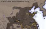
Lakes. There are about 3 million lakes in Russia. Among them, the deepest (1620 m) freshwater lake in the world is Baikal. Lake Baikal is famous not only as the most deep lake the world. It contains half of the fresh water reserves of our country (23 thousand km 3), or more than half of the runoff of all rivers in the world. Baikal water is one of the cleanest in the world. 336 rivers flow into Baikal, and only one flows out - the Angara. The fauna of Lake Baikal is unique. 3/4 of the species of Baikal animals live only here. Russia along with Kazakhstan, Azerbaijan, Turkmenistan and Iran, it comes to the shores of the world's largest Caspian Sea-lake (area - 371 thousand km 2).
The distribution of lakes throughout the country is uneven and depends on many reasons: geological structure and relief and the terrain, climatic conditions, the peculiarities of the occurrence of groundwater. The number of lakes decreases significantly to the south due to increased aridity climate a.
The origin of the lake basins is diverse (see Table 10).
Name the largest lakes in Russia. Which lakes in our country have pits of the same origin as the largest lakes in Africa? Remember the main reasons for the formation of swamps. How are formed The groundwater?
On a physical map of Russia, give examples of areas with big amount lakes.
Lakes are sources of fresh water, food products, raw materials. For example, salt is mined in lakes Elton and Baskunchak.

Lakes regulate the flow of rivers. Navigable routes pass along them. There are numerous resting places on their shores. Lakes actively influence other components of nature. They change the topography, shaping the bottom and shores. By filling their basins with peat, silt and salts, lakes create deposits of minerals.
Lesson content lesson outline support frame lesson presentation accelerative methods interactive technologies Practice tasks and exercises self-test workshops, trainings, cases, quests homework discussion questions rhetorical questions from students Illustrations audio, video clips and multimedia photos, pictures, charts, tables, schemes humor, anecdotes, fun, comics parables, sayings, crosswords, quotes Add-ons abstracts articles chips for the curious cheat sheets textbooks basic and additional vocabulary of terms others Improving textbooks and lessonsbug fixes in the tutorial updating a fragment in the textbook elements of innovation in the lesson replacing outdated knowledge with new ones For teachers only perfect lessons calendar plan for the year guidelines discussion agenda Integrated lessonsGlaciers, reservoirs, and The groundwater.
The groundwater - these are waters that are under the surface of the earth, that is, in the strata of rocks in the upper part of the earth's crust.
The groundwater - component natural waters and one of the most important geological resources. They play a huge role in feeding and regulating river flow, they are used for water supply. settlements, irrigation, treatment of people.
Groundwater is most widespread in the zone of excessive moisture with low relief.
Rocks, depending on their ability to pass water, are permeable (for example, sands) and waterproof (clays and crystalline rocks). Water that has passed through permeable rocks accumulates at depth, lingering there above the water-resistant layer and thereby forming aquifers. We observe the emergence of such a layer on the surface in the form springs.
Groundwater trapped between two watertight layers is called artesian.
In deep aquifers lie artesian waters ... Huge reserves of groundwater are concentrated in artesian basins (for example, in Russia - Moscow, West Siberian). On the first waterproof layer from the surface of the earth, groundwater... Their reserves and depth of occurrence depend primarily on climatic factors. In areas of excessive moisture (tundra, forest), the groundwater level is close to the day surface, and they often hit in the form springs and keys.
| Rice. 144. Geysers |
In the south, evaporation exceeds precipitation and the water table decreases. Passing through various rocks, groundwater dissolves them a little and comes to the surface in the form mineral springs... Exclusively high quality have fresh waters: this is the best drinking water... Mineral waters with an increased content of mineral substances and gases have effective medicinal properties... Balneological sanatoriums are being built in places of mineral water reserves. The area of the Caucasian Mineral Waters with their famous narzans is very famous: the sulfur waters of Pyatigorsk, the alkaline-salt waters of Essentuki, the carbonic waters of Kislovodsk, ferrous mineral water Zheleznovodsk.
Thermal waters, common in the Caucasus, Kamchatka, in Western Siberia, have an increased and high temperature(from + 30 ° to +300 ° C). Material from the site
Residential buildings, greenhouses are heated by thermal hot waters, they are used for spa treatment. The first geothermal power plant was built in Russia on the basis of the Pauzhetka deposit of high-thermal groundwater in Kamchatka. Periodically gushing hot springs are called geysers(fig. 144). They are confined to the volcanic areas of Kamchatka and Kuril Islands... The Valley of Geysers, located in the ridges of Eastern Kamchatka, is considered a natural wonder of Russia (Fig. 145).