To reveal the conditions for climate formation, it is necessary to determine its causes. They are called climate-forming factors. The main climate-forming factors are shown in the diagram.
On Earth, given a homogeneous, sufficiently moist surface, differences in the climate of any part of the Earth would depend on the radiation balance and atmospheric circulation. In this case climatic zones would be located strictly zonally and their boundaries would coincide with parallels. In fact, climate zones are not so ideally expressed. This is explained by the fact that the climate of different parts of the Earth is formed under the influence of all climate-forming factors.
Solar radiation is the source of energy for all processes occurring in the atmosphere. Due to solar radiation, heat is transferred from the sun through space. The spherical shape of the Earth determines climate differences depending on geographic latitude, and the inclined position of the Earth's rotation axis determines the seasonality of the climate. The circulation of air masses in the atmosphere affects the precipitation regime and the geography of its distribution on the globe, and air temperature.
To characterize the climate, it is very important to know how land and sea are distributed in a given place. The distance from the ocean shores to the interior of the continents affects the temperature and humidity regime and determines the degree of continentality of a given climate. Warm currents in the seas and oceans contribute to rising temperatures in coastal areas land and increased precipitation. Cold currents, on the contrary, lower the temperature on the outskirts of continents and prevent precipitation. Climate of the east and west coasts South America, Australia and Africa, located within the same tropical climate, is different. This is explained precisely by the presence of ocean currents there.
The influence of relief on climate is great. So, in the mountains different heights terrain above sea level climatic conditions vary; The climate is influenced by the direction of mountain ranges, which serve as an obstacle to wind and the invasion of air masses. Plains, on the contrary, allow continental or oceanic air masses to easily penetrate into neighboring areas.
Climate largely depends on the nature of the underlying surface, which refers to the components of the earth's surface that interact with the atmosphere. A forest, for example, reduces the daily temperature range of the soil and, therefore, the surrounding air. Snow reduces heat loss from the soil, but it reflects a significant amount of sunlight, and the Earth therefore heats up little.
With development on Earth human society a new factor has emerged that influences the planet’s climate. In cities, the air temperature is higher than in the surrounding areas. Air dust contributes to the formation of fogs and clouds, which leads to a reduction in the duration of sunshine and precipitation. Economic activity human pollution sometimes has an irreversible detrimental effect on the climate. For example, atmospheric pollution with sulfur dioxide and nitrogen oxides has given rise to the phenomenon of acid rain, which poisons soil and water bodies and destroys forests. These pollutants are transported over long distances by air masses and, together with precipitation, fall far from the sources of pollution. Only in the USA and Western Europe They have already destroyed more than 30 million hectares, which are the “lungs” of the planet. Acid rain also fall on Russian territory.
(Fig. 32).
Climate-forming factors, associated with geographic latitude, determine climate zonation. The distribution of water and land on the surface of the earth, as well as the topography of the continents, change the strict zonation of the climate.
The influence of latitude on climate
The most important factor in climate formation is geographic latitude. The angle of incidence of the sun's rays, and, consequently, the distribution of heat on the globe depends on it. A whole group of other climate-forming factors is associated with geographic latitude.
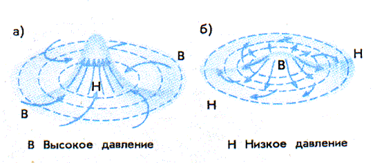
The influence of atmospheric circulation on climate
Uneven post-dullness solar radiation on different latitudes, in turn, determines the difference in atmospheric pressure and global process atmospheric circulation. This is a kind of air cycle, which involves heat and moisture transferred along with air masses.
The influence of geographical location on climate
One of the groups of climate-forming factors belongs to underlying surface. This is an azonal factor associated with the structure earth's crust and relief.
First of all, it is very important whether the climate is formed over the land surface or over the water surface. In the same latitudes it can be maritime or continental. Air masses over the oceans are cooler (at low and mid-latitudes in summer) and humid, with slight fluctuations in climate indicators (amplitudes). This is very clearly visible if we compare the distribution of air temperatures and atmospheric pressure V temperate latitudes Northern and Southern Hemispheres. IN Southern Hemisphere, where the Ocean is mainly located at these latitudes, isotherms and isobars lie relatively flat. In the Northern Hemisphere, where there is a lot of land, the contour lines are strongly curved.
For the land area it is also important remoteness from the oceans and seas. This factor determines the continental climate. The further inland the continent, the greater the fluctuations in air temperature and the less cloudiness and precipitation. For example, in the interior regions of Eurasia the climate is sharply continental; here the temperatures in July and January can differ by 60-70 °C.
The influence of relief on climate
A feature of the continents that also greatly influences the climate is: relief And absolute altitude. It is known that with altitude the air temperature decreases and the climate becomes colder. In addition, mountains can create a barrier to the path of air masses, and flat terrain, on the contrary, facilitate their invasion. For example, the southern slopes of the Himalayas resist the wet summer monsoon, so great amount precipitation falls on these windward slopes. But in the northeast of Vietnam there are mountain ranges medium height stretched out in meridional direction, therefore, cold air from the north often invades here through wide intermountain valleys, causing cold snaps and reducing rice yields.
The influence of currents on climate
Oceanic or sea te-cheniye, largely dependent on atmospheric circulation, have big influence on the climate, redistributing heat. If warm currents from low latitudes come to high latitudes, the climate of the coasts becomes warmer and wetter. Cold currents make the climate colder and drier. For example, the warm North Atlantic Current has a warming effect on the northwestern regions of Europe, while at the same latitudes in North America the cold Labrador Current passes, and there the climate is more severe. In the tropics, on the coasts past which cold currents flow, there are deserts.
Questions about this material:
The planet's climate is not constant, it changes over time. Sometimes the weather of one season of the current year can differ dramatically from the weather of the previous year. In addition, over the course of tens, and even more so hundreds and thousands of years, the climate situation changes significantly. This is influenced various factors. They can be classified as follows:
- planetary – solar radiation, air masses, rotation of the Earth around its axis and the Sun, moisture circulation;
- geographical - latitude of the area, influence of ocean currents, nature of the relief and underlying surface;
- anthropogenic – the results of human activity, in particular pollution of the biosphere.
Among this number of climate-forming factors, scientists identify three main ones that influence climate change. These are relief, solar radiation and circulation of air masses. It is these parameters that influence the formation of the climate of a particular point on the planet.
Amount of solar radiation
The amount of solar radiation that reaches the surface of the earth determines the heat, temperature of the atmosphere and the upper layer of the lithosphere. IN different parts On the planet, heat is distributed unevenly, depending on geographic latitude. The closer to the equator, the hotter it is, and the colder it is towards the poles. The influx of solar radiation is influenced by climatic indicators such as atmospheric circulation, precipitation, cloudiness and pressure. The flow of all life cycles planets.
Movement of air masses over earth's surface yu ensures climate change. They are continental and oceanic, depending on what part of the planet they formed over. During atmospheric circulation, clouds move, affecting the following weather indicators:
- precipitation;
- air humidity;
- temperature;
- wind direction and strength.
The main landforms are mountains and plains, which significantly influence the climate. Temperature, the pressure and wind speed in the mountains will differ sharply from the indicators flat surface. At the same time, the weather conditions differ in the foothills, on ridges, and slopes. The tops of the mountains are covered with glaciers and snow. On various shapes relief hits different quantities solar radiation, and mountains prevent the movement of air masses.
 Thus, the climate is influenced by various factors, among which the most important are solar radiation, topography and air masses. All these factors interact with each other and form the weather at a particular point. globe, and influence climate changes on the Earth as a whole.
CLIMATE [Greek. klima inclination (of the earth's surface to the sun's rays)], statistical long-term weather regime, one of the main geographical characteristics one area or another. The main features of the climate are determined
- incoming solar radiation
- air mass circulation processes
- the nature of the underlying surface.
From geographical factors, affecting the climate of a particular region, are most significant :
- latitude and altitude of the area,
- its proximity to the sea coast,
- features of orography and vegetation cover,
- presence of snow and ice,
- degree of air pollution.
These factors complicate latitudinal zonation climate and contribute to the formation of its local variations.
The concept of “climate” is much more complex than the definition of weather. After all, the weather can be directly seen and felt all the time, and can be immediately described in words or numbers from meteorological observations. To get even the most approximate idea of the climate of an area, you need to live in it for at least several years. Of course, you don’t have to go there; you can take many years of observational data from a meteorological station in this area. However, such material consists of many, many thousands of different numbers. How to make sense of this abundance of numbers, how to find among them those that reflect the properties of the climate of a given area?
The ancient Greeks thought that climate depended only on the inclination of the sun's rays falling on the Earth. In Greek, the word climate means slope. The Greeks knew that the higher the sun above the horizon, the steeper the sun's rays fall on the earth's surface, the warmer it should be.
Sailing north, the Greeks found themselves in places with a colder climate. They saw that the sun at noon was lower here than at the same time of year in Greece. But in hot Egypt, on the contrary, it rises higher. We now know that the atmosphere transmits on average three-quarters of the heat of the sun's rays to the earth's surface and retains only one-quarter. Therefore, first the earth's surface is heated by the sun's rays, and only then does the air begin to heat up from it.
When the sun is high above the horizon (A1), a section of the earth's surface receives six rays; when lower, there are only four rays and six (A2). This means that the Greeks were right that heat and cold depend on the height of the sun above the horizon. This determines the difference in climate between the eternally hot tropical countries, where the sun is at noon all year round rises high and twice
or once a year stands directly overhead, and icy deserts The Arctic and Antarctic, where for several months the sun does not appear at all.
However, not at the same geographical latitude, even in the same degree of heat, climates can differ very sharply from each other. For example, in Iceland in January average temperature air is almost 0°, and at the same latitude in Yakutia it is below -48°. In terms of other properties (amount of precipitation, cloudiness, etc.), climates at the same latitude can differ from each other even more than the climates of equatorial and polar countries. These climate differences depend on the properties of the earth's surface that receives the sun's rays. White snow reflects almost all the rays falling on it and absorbs only 0.1-0.2 parts of the brought heat, while black wet arable land, on the contrary, reflects almost nothing. Even more important for the climate is the different heat capacity of water and land, i.e. their different ability to store heat. During the day and summer, water heats up much more slowly than land and turns out to be colder. At night and in winter, water cools much more slowly than land, and thus turns out to be warmer.
In addition, it takes a lot of time to evaporate water in seas, lakes and wet land areas. a large number of solar heat. Due to the cooling effect of evaporation, the irrigated oasis is not as hot as the surrounding desert.
This means that two areas can receive exactly the same amount of solar heat, but use it differently. Because of this, the temperature of the earth's surface, even in two neighboring areas, can differ by many degrees. The surface of the sand in the desert on a summer day heats up to 80°, and the temperature of the soil and plants in the neighboring oasis turns out to be several tens of degrees colder.
In contact with the soil, vegetation cover or water surface. The air either heats up or cools down depending on what is warmer - the air or the earth's surface. Since it is the earth's surface that first receives solar heat, it mainly transfers it to the air. The hottest bottom layer The air quickly mixes with the layer lying above it, and in this way heat from the ground spreads higher and higher into the atmosphere.
However, this is not always the case. For example, at night the earth's surface cools faster than the air, and it gives off its heat to it: the heat flow is directed downward. And in winter, over the snow-covered expanses of the continents in our temperate latitudes and over the polar people, this process goes on continuously. The earth's surface here either does not receive solar heat at all, or receives too little of it and therefore continuously takes heat from the air.
If the air were motionless and there was no wind, then over neighboring differently heated areas of the earth's surface masses of air with different temperatures. Their boundaries could be traced to the upper reaches of the atmosphere. But the air is constantly moving, and its currents tend to destroy these differences.
Let's imagine that air moves over a sea with a water temperature of 10° and on its way passes over warm island with a surface temperature of 20°. Above the sea the air temperature is the same as the water, but as soon as the flow passes through coastline and begins to move inland, the temperature of its lowest thin layer begins to rise, and approaches the temperature of the land. Solid lines same temperatures- isotherms - show how heating spreads higher and higher in the atmosphere. But then the flow reaches the opposite shore of the island, enters the sea again and begins to cool - also from bottom to top. Solid lines outline the “cap” that is inclined and shifted relative to the island. warm air. This “cap” of warm air resembles the shape that smoke takes in strong winds.
 |
What we see in the figure is repeated everywhere over small and large differently heated areas. The smaller each such area, the lower above it will be the level in the atmosphere to which heating (or cooling) will have time to spread. air flow. If an air current from the sea passes to a snow-covered continent and moves many thousands of kilometers above it, then it will cool several kilometers upward. If a cold or warm area extends for hundreds of kilometers, then its influence on the atmosphere can be traced only hundreds of meters upward; with smaller sizes, the height is even less.
There are three main types climates - large, medium and small.
Great climate is formed under the influence only of geographic latitude and the largest areas of the earth's surface - continents, oceans. It is this climate that is depicted on world maps. climate maps. A large climate changes smoothly and gradually over large distances, at least thousands or many hundreds of kilometers.
Features of the climates of individual areas with a length of several tens of kilometers ( big lake, forest area, large city, etc.) are classified as a medium (local) climate, and smaller areas (hills, lowlands, swamps, groves, etc.) are classified as a small climate.
Without such a division it would be impossible to figure out which climate differences are major and which are secondary.
It is sometimes said that the creation of the Moscow Sea on the Moscow Canal changed the climate of Moscow. This is not true. The area of the Moscow Sea is too small for this.
Different influx of solar heat at different latitudes and unequal use of this heat by the earth's surface. They cannot fully explain to us all the features of climates if we do not take into account the importance of the nature of atmospheric circulation.
Air currents constantly transfer heat and cold from different regions of the globe, moisture from the oceans to land, and this leads to the emergence of cyclones and anticyclones.
Although the atmospheric circulation changes all the time and we feel these changes in weather changes, a comparison of different areas shows some constant local circulation properties. In some places, northern winds blow more often, in others - southern ones. Cyclones have their favorite paths of movement, anticyclones have theirs, although, of course, there are any winds in any place and cyclones are replaced by anticyclones everywhere. Cyclones cause rain.
Bibliography.
Ilyin M. Man and element. Ed. 4.M. “Young Guard” 1954.
Ruzalin G.I. The concept of modern natural science. M. 1997.
Mezentsev V.A. "Unusual phenomena in the atmosphere." M. Profizdat. 1959.
Galtsov A.P. How the weather is predicted. M., Voenizdat, 1954
Children's encyclopedia. Publishing house "Enlightenment" vol.1. 1967.
Concept of climate.
The study of climate - climatology is one of the most important parts of meteorology and at the same time a private geographical discipline. The subject of climatology is the study atmospheric processes, formed from the influence of astronomical and complex complex of physical and geographical conditions. These processes arise mainly under the influence of solar radiation, causing the transfer of air and its transformation as a result of the exchange of heat and moisture with the surface of the seas and oceans. In every region of the globe. The nature of climatic processes, frequency and occurrence, duration and order of change is determined by latitude this place͵ time of year, relief conditions and such global factors as the distribution of oceans and land. The concepts of weather and climate are often confused; there is a huge difference between these concepts. Weather is the physical state of the atmosphere over a given area and beyond. given time, characterized by a certain combination of meteorological elements. The climate is characterized by a long-term weather regime, and by long-term regime we mean not only the prevailing, but also generally possible weather conditions in a given area. Local features climate caused by the heterogeneity of the structure of the active surface is called microclimate. In addition to microclimate, there is also a local climate or mesoclimate (climate of a lake, clearing, etc.).
The most important climate-forming factors are solar radiation, atmospheric circulation and the nature of the underlying surface. Under their joint influence, climates are formed in various parts globe. The physical mechanisms that determine external influences on the climate system, as well as the main interactions between the links of the climate system, are called climate-forming factors. These factors can be divided into 2 groups.
1. External climate-forming factors - in turn, can be divided into 2 groups:
a. Astronomical factors (luminosity of the sun, position of the earth’s orbit, characteristics of the earth’s orbital motion, inclination of its axis to the orbital plane, speed of rotation around its axis)
b. Geophysical factors - size, mass of the earth, its own gravitational and magnetic field, internal heat, determining geothermal heat sources and volcanism
2. Internal. The composition of the atmosphere (both its constant components and variable thermodynamic active impurities), its mass and the composition of the ocean, features of the distribution of land and ocean, the topography of the land surface, the structure of the active layer of land and ocean.
Climate classification.
How to analyze the patterns of climate formation within global system. Likewise, to apply climatology in solving a number of practical problems, it is necessary to know not only the distribution of individual climatic values across the globe or a large area, but also the climatic complex as a whole. Zoning makes it possible either to identify areas where climatic conditions for a given application are different, or to identify climatic analogues in different parts of the globe, allowing rational use of experience for very remote areas.
List of climate classifications:
1. Botanical - 5 zones were identified, which in one form or another were taken into account in subsequent climate classifications and were carried out according to the needs of plants according to climatic factors(heat, temperature)
2. W. Köppen’s classification – identifies 5 latitudes climatic zones, denoted by capital letters Latin alphabet. (characterized by the presence or absence of cold and warm seasons, annual course hydration.
3. Hydrological – based on the fact that rivers are a product of climate (the main climate-forming factor).
4. Landscape and botanical L.S. Berg - created for zoning landscape zones and is mainly based on the distribution of the plant community.
5. Soil - associated with the name of Dokuchaev. It was created in 1897, taking into account zonal and ozonal varieties of soils, taking into account the climate of the present and geological past, forming soils, weathering processes, partially relief and other features of soil formation, as well as vegetation and fauna.


