The deserts and semi-deserts are anhydrous, dry areas of the planet, where no more than 25 cm of precipitation falls per year. The most important factor in their formation is the wind. However, no hot weather is observed in all deserts, some of them, on the contrary, are considered the most cold regions of the Earth. Representatives of flora and fauna in different ways adapted to the harsh conditions of these areas.
How do deserts and semi-deserts arise?
The reasons thanks to which the desert occurs, there are many. For example, there are little precipitation because it is located at the foot of the mountains, which their crests close it from the rain.
Ice deserts were formed for other reasons. In Antarctica and the Arctic, the main snowy mass falls on the coast, to the internal areas, snow clouds practically do not reach. The level of precipitation is basically much varied, for one snowfall, for example, the annual norm may fall. Such snownotes are formed hundreds of years.
Hot deserts are distinguished by a variety of relief. Only some of them are completely covered with sand. The surface of the majority is littered with pebbles, stones and other different rocks. Deserts are almost completely open for weathered. Strong gusts of the wind pick up the fragments of small stone and hit them about the rocks.
In the sandy deserts, the wind transfers sand around the territory, creating wave-like injuries that are called dunes. The most common type of dunes - verakhans. Sometimes their height can reach 30 meters. Comb dunes can have a height of up to 100 meters and stretch 100 km.

Temperature mode
The climate of the desert and semi-desert is quite diverse. In some regions, daytime temperatures can reach 52 o C. This phenomenon is associated with the lack of clouds in the atmosphere, therefore, nothing saves the surface from direct sunlight. At night, the temperature is very much reduced, which is again due to the absence of clouds that are able to delay the heat emitted by the surface.
In the hot deserts rain - the phenomenon is rare, but sometimes the strongest rains occur here. After the rain, the water is not absorbed into the ground, and rapidly flows from the surface, washing the soil particles and pebbles in dry canals that are called Wadi.
Desert location and semi-desert
On the continuity, which are located in northern latitudes, are deserts and semi-deserts of subtropical and sometimes there are also tropical - in Indo-Ganga lowland, in Arabia, in Mexico, in the south-west of the United States. In Eurasia, unnecessary desert areas are located in the Central Asian and South Kazakh plain, in the basin of Central Asia and in the Orange Highlands. The Central Asian deserted formations are peculiar to a sharply continental climate.
In the southern hemisphere of the desert and semi-desert meet less often. There are such deserted and semi-desert formations such as Namib, Atakama, deserted formations on the coast of Peru and Venezuela, Victoria, Kalahari, Gibson Desert, Simpson, Grand Character, Patagonia, a large sandy desert and semi-desert carru in South-West Africa.
Polar deserts are located on the mainland islands of the Parishery of Eurasia, on the Islands of the Canadian Archipelago, in the north of Greenland.
Animals
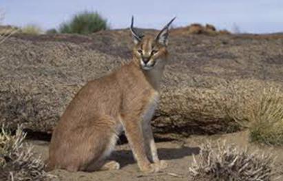
The animals of deserts and semi-deserts for many years of existence in such localities managed to adapt to harsh climatic conditions. From the cold and heat they are hidden in underground nora and feed on, mainly underground parts of plants. Among the representatives of the fauna there are many types of carnivorous: fenwiths, puma, coyota and even tigers. The climate of the desert and semi-desert contributed to the fact that many animals had a great thermoregulation system developed. Some desert residents can withstand fluid loss up to a third of their weight (for example, Gecko, camel), and among invertebrates there are species that are able to lose water to two thirds of their weight.
In North America and Asia there is a mass of reptiles, especially many lizards. Snakes are also quite common: ephs, various poisonous snakes, removal. From large animals there are saigas, kulans, camels, a vilorog, which recently disappeared (in captivity it can still be found).
The animals of the desert and semi-deserts of Russia are a wide variety of unique fauna representatives. Sandstone hares, hedgehogs, Kulana, Jameman, poisonous snakes inhabit the country's desert regions. In the deserts that are located in Russia, you can also meet 2 types of spiders - Karakurt and Tarantula.
In the polar deserts a white bear, sheep, sands and some species of birds live in the polar deserts.

Vegetation
If we talk about vegetation, then in deserts and semi-deserts there are various cactus, severe cereals, shrubs-psammofit, ephedra, acacia, saksaululy, soap palm trees, edible lichen and others.
Deserts and semi-deserts: soil
Soil, as a rule, is poorly developed, water-soluble salts prevail in its composition. Among the ancient alleavial and foresawid deposits, which are reworked by the winds. Gray-brown soil is inherent for sublime plain sites. Solonchaki is also characteristic of the desert, that is, soils that contain about 1% of the easily soluble salts. In addition to the deserts, Solonchaki are also found in the steppes and semi-deserts. Groundwater, which contain salts, are deposited in its upper layer when the soil is reached, resulting in a soil salinization occurs.
Completely others are characteristic of such climatic zones as subtropical deserts and semi-deserts. Soil in these regions has a specific orange and brick-red. Noble to her shades, she received the appropriate name - red and yellow-bees. In the subtropical belt in the north of Africa and in South and North America there are deserts where the serosons were formed. In some tropical desert formations, red-yellow soils were formed.

Natural and semi-desert are a huge variety of landscapes, climatic conditions, vegetable and animal world. Despite the harsh and cruel temper of the desert, these regions became their home for many species of plants and animals.
The exceptional peculiarity and antiquity of the vegetable and animal world of Australia is explained by its long-term isolation. Most plant species (75%) and animals (90%) of Australia are endemics, i.e. they are no longer found anywhere in the world. Among the animals little mammals, however, extinct views are preserved on other continents, including the samples (about 160 species). The characteristic representatives of the Australian flora are eucalyptus (600 species), acacia (490 species) and Kazuarian. The mainland did not give the world of valuable cultivated plants.
Australia is located in four geographic belts - from the subequatorial to moderate. The change of natural zones is due to changes in temperature and precipitation mode. The plain nature of the relief contributes to a well-pronounced, violated only in the east. The main part of the continent lies in tropical latitudes, so tropical deserts and semi-deserts occupying half of the continental square were obtained the greatest development.
The central parts of the mainland in two geographic belts (tropical and subtropical) are occupied by deserts and semi-deserts. Australia is fairly called the desert continent (big sandy, large desert Victoria, Gibson desert, etc.). In the West Australian plateau in the conditions of a tropical continental climate, tropical deserts and semi-deserts dominate. In the stony and sandy along the river river rags stretch a parel of Casuarine. In the depressions of clay semi-deserts there are overgrown with swans and saline types of acacia and eucalyptus. For the deserts are characteristic of the "pillows" of a bushy cushion spinifex. Soil semi-desert - serous, deserts - primitive stony, clay or sandy.
In the south of the mainland in the subtropics of the desert and semi-deserts occupy the plain nullarbor ("refraisable") and the lowland of Murree-Darling. They are formed under the conditions of a subtropical continental climate on brown semi-desert and gray-brown soils. Against the backdrop of dry rare cereals, wormwood and Solianki occurs, there is no wood-shrub vegetation.
The most acute in Australia is the problem of deficiency. Previously, it was solved by pumping groundwater from numerous wells. But at present there is a decrease in the level of water in the artesian basins. The depletion of underground water reserves on a par with a decrease in the fullness of rivers, the lack of water in Australia exacerbated, forcing it to implement programs for its savings.
One of the ways to conserve nature is the creation of specially protected natural territories. They occupy 11% of the continent. One of the most visited is the Kosyushko Park in Australian. In the north, one of the world's largest parks in the world, which is taken under protection not only by wetlands, serving the habitat of many endemic birds, but also caves with rock painting of aborigines. In the park, blue mountains are guarded by stunning mountain landscapes with variety of eucalyptus forests. Under the protection of the nature of the desert (Parks Big Desert Victoria, Simpson-Desert). UNESCO World Heritage Site in Uluru-Katata Park is recognized as a sacred giant monolith from red sandstone Ayers-Rock. The fabulous world of corals is guarded in the underwater park of a large barrier reef.
In a large barrier reef, there is the greatest variety of corals on the planet (up to 500 species). The threat, in addition to pollution of coastal waters and poaching, is a nastain crown of the marine star "Ternist". Increasing the temperature of ocean waters due to global climate warming entails the discoloration and death of corals.
The main feature of the animal and vegetable world of Australia is the predominance of endemics. Australia is the most deserted continent. Global, exhaustion of water resources, depletion of the plant and animal world pose a threat to the nature of the mainland. Especially protected natural territories occupy 11% of the continent.
Ministry of Education of the Moscow Region Moscow State Regional University
Geographer-ecological faculty
EXTRAMURAL
Specialty "Geoecology"
Course work
by subject
"General Ecology"
"Desert Australia"
Performed:
student IV course group 42
Bubentsova O.A.
Moscow 2013 year
1.General Physico-Geographical Description
The Australian Union is the only state in the world engaged in the territory of the whole continent. The Australian continent is located entirely in the southern hemisphere, and its name itself comes from Latin Terra Australis Incognita (unknown South Land) - so called ancient geographers mysterious southern continent, the place of which they were unknown, but the existence of which they assumed. The Australian continent is washed from all sides by the oceans - quiet, Indian and South.
The Australian Union includes in addition to his own mainland, the island of Tasmania and small islands located off the coast of the continent. Under the control of Australia are so-called external territories : Islands and island groups in the quiet and Indian Ocean.
Square of the Australian Union - 7.7 million square meters. km. The population is small - only 14 million people. At the same time, the overwhelming majority of Australians live in cities, including almost half - in the two largest: Sydney (over 3 million inhabitants) and Melbourne (about 3 million inhabitants). The capital of Australia - Canberra. Australia is one of the most urbanized countries of the world.
The relief of Australia is dominated by the plains. About 95% of the surface does not exceed 600 m above sea level. Most of Australia lies in the tropics, north - in subequatorial latitudes, south - in subtropical. In Australia, the height of the plains are small, this causes constantly high temperatures on all the mainland. Australia is entirely entirely within the summer isotherm 20 OS - 28 OS, Winter 12 OS - 20 OS.
The position of most Australia in the continental tropical belt sector causes the climate dryness. Australia is the most arid from the continents of the Earth. 38% of the Australia Square receives less than 250 mm of precipitation per year. About half of the territory of Australia occupy deserts and semi-deserts.
Australia is rich in a variety of minerals. New discoveries of mineral ores made on the continent over the past 10-15 years have put forward a country for one of the first places in the world in stocks and mining of such minerals as iron ore, bauxite, lead-zinc ores. The main deposits of metal minerals and deposits will be discussed in the next section of the work. Of non-metallic minerals there are various clay, sands, limestone, asbestos, as well as mica.
Rivers flowing from the eastern slopes of a large waterprooper - short, in the upwards flow in narrow gorges. Here they may well be used, and partly are already used to build hydropower plants. When leaving the coastal plain, the river slows down their current, their depth is increasing. Many of them are even available for large ocean vessels.
On the western slopes of the large waterproof ridge, they take the beginning of the river, laying their way to internal plains. In the area of \u200b\u200bMount Kosyushko, the most popular river in Australia - Murray begins. Power p. Murray and its ducts mainly rain and to lesser extent snow. Almost all the rivers of the Murree system are built dams and dams, near which reservoirs are created, where flooded water used for irrigation of fields, gardens and pastures are collected.
The rivers of the North and Western coasts of Australia shallow water and relatively small. The longest of them - Flinders falls into the Bay of Carpenary. These rivers have raindrops, and their aquifers change greatly at different times of the year.
Rivers whose flows are sent to the inner fields of the mainland, such as Cooper Creek (Barca), Diamant-Ina, etc., are deprived of not only a constant flow, but also a constant, distinctly pronounced bed. In Australia, such temporary rivers are called cries. They are filled with water only during short-term showers.
Most Lakes Australia, like rivers, feed on rainwater. They do not have a permanent level, nor the flow. In the summer of the lake dry and constitute a shallow salt challenge.
Since the Australian mainland has long time, starting from the middle of the Cretaceous period, was insulated from other parts of the globe, its plant world is very peculiar. Of the 12 thousand species of higher plants, more than 9 thousand - endemics, i.e. Grow out only on the Australian continent. Among endemics are many types of eucalyptus and acacias, the most typical of Australia plants. At the same time, there are also plants that are inherent in South America (for example, South Beech), South Africa (representatives of the protein family) and the islands of the Malay Archipelago (Ficus, Pandanus, etc.). This suggests that many millions of years ago there were land connections between the continents.
Since the climate of most of the territory of Australia is distinguished by a sharp dryness, dubbed plants dominate in her flora: special cereals, eucalyptus, umbrella acacia, succulent trees (bottle and dr.). In the extreme north and north-west of the country, where hot and warm northwestern monsions bring moisture, rain rainforests grow. In their woodwork, gigantic eucalyptus, ficuses, palm trees, pandanas with narrow long leaves and other places on the coast itself there are bamboo. In those places where the shores are flat and etc, mangall vegetation develops. Rainforests in the form of narrow galleries are stretched at relatively small distances inside the mainland according to the valleys of rivers.
The farther to the south, the land becomes climate. Forest cover gradually radically. Eucalyptus and umbrella acacia are located in groups. This is a zone of wet savannah, stretching in the latitudinal direction south of the rainforest zone. For the central deserts of the parts of the mainland, where it is very hot and dry, characteristic thick, almost impassable thickets of prickly low shrubs consisting mainly of eucalyptus and acacia.
The eastern and southeastern slopes of a large waterproof ridge, where many precipitation falls, covered with dense tropical and subtropical evergreen forests. Most of all in these forests, as well as everywhere in Australia, Eucalyptus. Above in the mountains, the admixture of pine damarra and beech are noticeable. Shrub and herbal cover in these forests are diverse and dense. In less wet variants of these forests, the second tier form herbal trees. On the island of Tasmania, except eucalyptus, many evergreen beecles, related to South American species. In the southwest, the mainland of the forest covers the Western slopes of the Darling Ridge, facing the sea. These forests are almost completely consisting of eucalyptus reaching considerable heights. The number of endemic species here is especially great. In addition to eucalyptus, bottle trees are widespread.
In general, the forest resources of Australia are small. The total area of \u200b\u200bforests, including special areas, consisting mainly of species having soft wood (mainly pines radiant), at the end of the 70s ranged only 5.6% of the country's territory.
In Australia, in the natural sequence, all types of soils are presented, characteristic of tropical, subequatorial and subtropical natural belts.
In the area of \u200b\u200bwet rainforests in the north, red soils are common, condensed towards the south of red-brown and brown soils in wet savannas and gray-brown in dry savanna. Red-brown and brown soils containing humus, a bit of phosphorus and potassium, are valuable for agricultural use. Within the red-brown soil zone, the main crops of Wheat Australia are located.
The Australian continent is located within the three main warm climatic belts of the southern hemisphere: subequatorial (in the north), tropical (in the central part), subtropical (in the south). Only a small part about. Tasmania is within a moderate belt.
The larger territory of the country prevails a dry and hot continental climate of the tropical belt. The northern part of Australia is located in a sub-screen climatic belt - here all year round, in summer the humidity is very high and in the winter - low. On the eastern coasts, hot and wet all year round. The subtropical belt in which the southern part of Australia is located mainly continental climate - hot and very dry summer and cool wet in winter. The south-west coast of Australia is in the power of the Mediterranean climate with a hot dry summer and soft rainy winter. The southeastern part of Australia and the northern part of Tasmania Island are under the influence of a monsoon climate with a hot rainy summer and soft dry winter. The southernmost of the island of Tasmania is located in a temperate belt with a soft humid climate.
The hot climate and a minor and uneven precipitation falling on most of the mainland lead to the fact that almost 60% of its territory is deprived of the flow of the ocean and have only a rare network of temporary watercourses.
.Desert Australia
Australia is often called the desert continent, because About 44% of its surface (3.8 million square meters) occupy arid territories, of which 1.7 million square meters. km - desert.
Even the rest is seasonally dry.
This suggests that Australia is the most arid mainland on the globe.
The deserts of Australia are a complex of desert regions located in Australia.
The deserts of Australia are located in two climatic belts - tropical and subtropical, and most of them take the last belt.
Large sandy desert
Big Sand Desert or Western Desert - Sandy Salon Desert<#"justify">Big desert Victoria
Big Desert Victoria - Sandy Salon Desert<#"justify">Gibson desert
Gibson Desert - Sand Desert<#"justify">Small sandy desert
Small sandy desert - sandy desert<#"justify">Desert Simpson
Simpson Desert - Sand Desert<#"justify">The average January temperature is 28-30 ° C, July - 12-15 ° C.
In the northern sediments less than 130 mm, the dry bed of screams<#"justify">Tama
Tans - rocky sandy desert<#"justify">Desert Stshchetsky
Stshetsky desert is located in the south-east of the mainland in the states of South Australia, the new South Wales and Queensland. The desert area is 1% of Australia Square. It was opened by Europeans in 1845 and was named after the Polish researcher Pavel Stshhetsky. Also in Russian sources is called Lottle Desert.
Stone desert Start
The stone desert, which occupies 0.3% of the territory of Australia, is located in the state of South Australia and is a cluster of sharp small stones. Local aborigines did not sharpen their arrows, but simply gained stone tips here. The desert received its name in honor of Charles Start, who in 1844 tried to reach the center of Australia.
Desert Tirari
In this desert, located in the state of South Australia and is 0.2% of the mainland area, one of the toughest climatic conditions in Australia, due to high temperatures and practically lack of rains. In the desert Tirari, there are several salted lakes, including Lake Air<#"justify">3.Geily world
Long-term isolation of Australia from other continents led to the exceptional peculiarity of the fauna of this mainland, and in particular its desert area.
The species endemism is 90%, and the other types of subendemic, that is, they come out in its distribution beyond the limits of the desert, but not beyond the continuation of the mainland as a whole. From endemic groups there are: sample moles, Australian stones, lizards of scales.
In Australia, there are no representatives of the detachments of predatory, hoofs, insectivores, hares; The rodent detachment is represented only by the types of mouse subfamily; Of the birds there are no squad of Ryabkov, a family of pheasan, church, reels and a number of others. Fauna Reptile also had an impossible: here did not penetrate the types of families of Laceritsa Lacentid, Refuge, Phajukovy and Jambol Snakes. Due to the lack of mentioned and number of other animals, local, endemic families and childbirth as a result of wide adaptive radiation mastered free ecological niches and developed a number of convergent forms in the process of evolution.
Among the aspid snakes there were species, morphologically and ecologically similar to viper, lizards of the Szindy family successfully replaced Lacentid, but especially many convergent forms are observed in silent mammals. They are environmentally replaced by insectivores (sampling chopers), tushkanchikov (sample tubes), large rodents (breeding or charts), small predators (stembed cunits) and even to a large extent hoof (Wallaby and Kangaroo). Small mile-like rodents widely inhabit all types of deserts (Australian mouse, a carcass mouse and others). The role of large herbivore animals in the absence of hoofs is performed by the championships of the Kangarov family: a kiestheli kangaroo inhabited in the Gibson desert; Giant redhead kangaroo, etc. Small predatory championships in appearance and biology are similar to the exchanging lights of the old light (Grebdahvosta Khamccumber, Tolstokhavosta Khamccumber). The underground lifestyle leads silent moles, inhabit sand plains.
Temple badgers dwell in the Simpson desert. The largest aboriginal predator in the deserts of Australia is a sampling center. About 10 thousand years ago, a person entered the Australian continent and settled it. Together with a person came here and the dog is a permanent satellite of the primitive hunter. Subsequently, the wild dogs spread widely in the wildlife deserts, forming a stable form called Dingo's dog. The emergence of such a major predator caused the first significant damage to the aboriginal fauna, especially various championships. However, the greatest damage of local fauna was applied after Europeans appeared in Australia. Or deliberately, or by chance they brought here a whole range of wild and pets (European rabbit - they quickly spread up, settled in large colonies, destroyed the already meager vegetation cover). Widely settled throughout the center of Australia, an ordinary fox and a house mouse. In the central and northern regions often there are small herds of wild donkeys or single single-burnt camels.
Near the temporary waterproofs in the hot clock in the desert there are many birds (parrots, reels Zebra, reels-emblems, pink cockatoo, diamond bars, birds of emu). Insectivorous birds do not need water and inhabit the desert areas away from all sources of water (Australian walkers, Australian Slavs). Since real larks did not penetrate the desert of Australia, their ecological niche was taken by representatives of the family of the Slavkov, who adapted to the terrestrial lifestyle and externally surprisingly similar to the larks. Flat chubby and stony plains, salt chains with rare swans inhabitants inhabit Australian heater. In the thickets of shrub eucalyptus - a large chain of a large-wheel or weed chicken lives. In all desert habitats, you can see black Australian raven. Reptiles in the Australian deserts are extremely varied (families of crystal, gecko, agamous, aspid). Warana is achieved in the deserts of Australia the greatest diversity compared to other regions. Many snakes, insects (Chernotelka beetles, beetles-scorer and others).
.Vegetable world
All the deserts of Australia lie within the Central Authority Area of \u200b\u200bthe Australian Floristic Kingdom. Although the species wealth and level of endemism, the deserted flora of Australia is significantly inferior to the flora of the Western and northeastern regions of this mainland, however, compared with other deserted regions of the globe, it is also distinguished by the number of species (more than 2 thousand), and the abundance of endemics. Species endemism reaches 90% here: has 85 endemic clans, of which 20 are in the family of comprehensive, or astera, 15 - moored and 12 - cruciferous.
Among endemic clans, there are background desert cereals - Mitchell's grass and triodia. The large number of species are presented families of legumes, myrth, protein and comprehensive. Significant species diversity is demonstrated by the childbirth eucalyptus, acacia, protein - Grevilleia and Hakeya. In the very center of the mainland, in the gorge of the desert mountains McDonnell, narrowly emerged endemics are preserved: a low-spirited palm tree and macrozamia from cicades.
Even some types of orchids are settled in the deserts - ephemers, germinating and blooming only in a short period after the rains. Rosyanka penetrate. Intergundable decreases and the lower part of the slopes of a variety of curtains of the prickly cereal of triodies. The upper part of the slopes and the crests of the barhane are almost completely devoid of vegetation, only individual curtals of the prickly cereal of Siegokhloe settle on the bulk sand. In the interbarch decreases and on flat sandy plains is formed rarending by the ancient from the casuarine, individual copies of the eucalyptus, acacia of the navel. The shrub tier is formed by the protein - it is a hake and several types of Grevilleia.
Sleeping, ragotia and evchylene appear on a slightly saline location. After rains, intergundable decreases and the lower parts of the slopes are covered with colorful ephemers and ephemeroids. In the northern regions in the sands in the wilderness of the Simpson and the large sandy species composition of the background, there are somewhat changing: there are other types of triodics, plectrhne and Chenoborod; It becomes a variety and species composition of acacia and other shrubs. Along the line of timewater, gallery forests are formed from several species of large eucalyptus. Eastern outskirts of the Big Desert Victoria are occupied by sclerophilic shrub thickets Mom scrub. In the south-west of the big desert, Victoria dominate the lowest eucalyptus; The herbal tier form a kangaroch grass, the types of the pitch and others.
ARIDA-Australia's arid are very weakly populated, but vegetation is used for grazing.
Climate
In the tropical climatic belt engaged in the territory between 20 and the 30th parallel in the desert zone, a tropical continental desert climate is formed. The subtropical continental climate is distributed in the southern part of Australia, adjacent to the Great Australian Bay. These are the outskirts of the big desert Victoria. Therefore, in the summer, from December to February, the average temperatures reach 30 ° C, and sometimes above, and in the winter (July - August) decrease on average to 15-18 ° C. In some years, the entire temperature period can reach 40 ° C, and the winter night next door to the tropics drops to 0 ° C and below. The amount and territorial placement of precipitation is determined by the direction and nature of the winds.
The main source of moisture serve "dry" Southeast Passats, since most of the moisture is delayed by the mountain ranges of East Australia. The central and western part of the country, corresponding to about half of the area, receive an average of about 250-300 mm precipitation per year. The smallest amount of precipitation, from 100 to 150 mm per year, gets the Samenson desert. The seeding season in the northern half of the continent, where the monsoon change of winds is dominated, is timed to the summer period, and, in the southern part of it, during this period there are arid conditions. It should be noted that the number of winter precipitation in the southern half decreases as the mainland is progressing, rarely reaching 28 ° Yu.Sh. In turn, summer sediments in the northern half, having the same trend, do not apply to the south of the tropics. Thus, in the zone between the tropical and 28 ° Yu.Sh. There is an aridness belt.
For Australia, the excessive variability of average annual precipitation and the unevenness of their fallout during the year are characterized. The presence of long arid periods and high average annual temperatures that dominate the large part of the continent, determine the high annual values \u200b\u200bof evaporation. In the central part of the mainland, they make up 2000-2200 mm, decreasing to its edge parts. The surface waters of the continent are extremely poor and extremely unevenly distributed through the territory. This is especially true of the deserted Western and central regions of Australia, which are almost unprecedented, but constitute 50% of the continent.
Hydrography
australian desert fauna precipitation
Features of the flow in Australia and the following numbers are well illustrated on the islands close to it: the flow of the rivers of Australia, Tasmania, New Guinea and New Zealand is 1600 km3, layer of flow - 184 mm, i.e. Low more than in Africa. A car of one Australia is only 440 km3, and the thickness of the flow layer is only 57 mm, that is, several times less than on all other continents. This is due to the fact that most of the mainland, unlike islands, receives little precipitation and there are no high mountains and glaciers within its limits.
The field of indoor flow includes 60% of the Australian surface. Approximately 10% of the territory has stock in the Pacific Ocean, the rest belongs to the Indian Ocean basin. The main watershed of the mainland is a large waterproof ridge, from whose slopes the largest and largest rivers flow. Nutrition of these rivers is almost exclusively rain.
Since the eastern slope of the ridge is short and steep, then short, fast, winding rivers flow toward coral and Tasmanov seaside. Getting more or less uniform nutrition, they are the largest rivers of Australia with a well-pronounced summer maximum. Crossing the ridges, some rivers form thresholds and waterfalls. The length of the largest rivers (Fitzroy, Berdekin, Hunter) - several hundred kilometers. In the lower current, some of them shipping for 100 km and more and in the mouths are available for ocean courts.
The rivers of North Australia and the Arafur and Timor Sea are also full-flowered. The most significant are those that flow from the northern part of the large waterproof ridge. But the rivers of the North of Australia, due to a sharp difference in the number of summer and winter precipitation, have less uniform mode than the rivers of the East. They are overwhelmed with water and often leave the shores during the summer monsoon rains. In winter, it is weak narrow watercourses, in the upper reaches of drying places. The largest rivers of the North - Flinders, Victoria and the Horde - in the summer of shipping in the lower course of several tens of kilometers.
Permanent watercourses are also in the southwest of the mainland. However, during the dry summer season, almost all of them turn into chains of shallow polluted reservoirs.
In the desert and semi-desert internal parts of Australia there are no constant watercourses. But there is a network of dry beds, which are the remnants of the previous developing water network, which formed in the conditions of the plvaist era. These dry beds are filled with water after rains for a very short time. Such periodic watercourses are known in Australia called "screams". They are especially numerous on the central plain and are directed toward the selfless breathing Lake Eyre. Cars of plain Nallarbor is devoid of even periodic watercourses, but has an underground water network with a drain towards the Great Australian Bay.
The soil. Landscape
The soil cover desert is peculiar. In the northern and central regions, red, red-brown and brown soils are distinguished (characteristic features of these soils are acidic reaction, staining iron oxides). Serious soils are widespread in the southern parts of Australia. In Western Australia, descendant soils are found in Western Australia. For large sandy desert and large desert, Victoria is characteristic of red sandy desert soils. In the faceless internal depressions in the south-west of Australia and in the pool of Lake Eyre, salt marshes and solonts are widely developed.
The Australian deserts in landscape are divided into many different types, among which the most often Australian scholars allocate mountain and foothill deserts, deserts of structural plains, rocky deserts, sandy deserts, clay deserts, plan. The most common sandy deserts, occupying about 32% of the continent. Along with the sandy deserts, stony deserts also have widespread areas (they occupy about 13% of the area of \u200b\u200barid territories. Popular plains are alternating of large-frame deserts with dry beds of small rivers. This type of desert is the source of most of the country's desert watercourses and always serves as a habitat of aborigines. Desert The structural plains are found in the form of a plateau with a height of not more than 600 m above sea level. After the sandy deserts, they are most developed, occupying 23% of the area of \u200b\u200barid territories dedicated mainly to Western Australia.
Population
Australia is the least inhabited mainland of the Earth. About 19 million people live on its territory. The total population of Oceania Islands is about 10 million people.
The population of Australia and Oceania is divided into two unequal, various on the origin of the group is indigenous and proven. The main inhabitants on the mainland are a bit, and on the islands of Oceania, with the exception of New Zealand, Hawaiian Islands and Fiji, they constitute the overwhelming majority.
The beginning of scientific research in the field of anthropology and ethnography of the peoples of Australia and Oceania was postponed in the second half of the XIX century. Russian scientist N. N. Miklukho-Maclay.
Like America, Australia could be populated by a person not as a result of evolution, but only from the outside. As part of its ancient and modern fauna, not only primates are missing, but in general all the highest mammals.
Within the mainland, no traces of early Paleolithic were found. All known findings of the residues of the fossil residues of a person have features of Homo Sapiens and belong to the upper paleolyte.
The indigenous population of Australia has such pronounced anthropological signs as: dark brown skin, wavy dark hair, a significant growth of beard, a wide nose with low stand. The persons of the Australians are distinguished by prenatamism, as well as massive Visbrovier. These features bring the Australians with Vedas Sri Lanka and some tribes of Southeast Asia. In addition, the following fact deserves attention: The most ancient fossil residues found in Australia have close similarities with bone residues found on the island of Java. Approximately relate to the time coinciding with the last glacial era.
Of great interest is the problem of the path in which the settlement of Australia and the islands close to it occurred. Along the way, the question of the time of mastering the mainland is solved.
Undoubtedly, Australia could only be settled from the north, that is, on the part of Southeast Asia.
This is confirmed by both the anthropological peculiarities of modern Australians and Paleoanthropological data, which was mentioned above. It is also obvious that a modern type man is penetrated into Australia, i.e., the metabolism setting could not happen before the second half of the last glacial.
Australia for a long time (obviously, from the end of the mesozoic) exists isolated from all other continents. However, during the Quaternary period, land between Australia and Southeast Asia was extensive than currently. A continuous land "bridge" between the two continents, obviously, never existed, since if he were, on him it would have to penetrate the Australia Asian fauna. In all likelihood, in the late quirky time at the place of shallow pools, separating Australia from New Guinea and the South Islands of the Sunda Archipelago (their modern depths do not exceed 40 m), there were extensive land plots formed as a result of repeated fluctuations in the sea level and sushi raising. Torresov Straitov, separating Australia from New Guinea, may have been formed quite recently. The probe islands could also periodically be interconnected with narrow sushi strips or shames. Most terrestrial animals could not overcome such an obstacle. People gradually, on land or overcoming shallow straits, penetrated through the Small Stern Islands on New Guinea and on Australian Mainland. At the same time, the settlement of Australia could occur both directly from the Stern Islands and the islands of Timor and through New Guinea. This process was very long, he probably stretched over the whole millennium over the late Paleolithic and Mesolithic. Currently, on the basis of archaeological finds on the mainland, it is assumed that the person there appeared for the first time about 40 thousand years ago.
Very slow was the process of distribution of people on the mainland. The settlement went along Western and Eastern coasts along the Western and East, and in the east there were two ways: one - along the shore itself, the second - west of the large waterproof ridge. Two these branches converged in the central part of the mainland in the area of \u200b\u200bLake Air. In general, Australians are distinguished by anthropological unity, which indicates the formation of their main signs after penetration into Australia.
The culture of Australians is very distinctive and primitive. The originality of culture, originality and proximity to each other languages \u200b\u200bof various tribes testify to the continuous isolation of Australians from other peoples and their autonomous historical development up to the new time.
By the beginning of European colonization in Australia, about 300 thousand aborigines, divided by 500 tribes, lived. They pretty evenly settled all the mainland, especially his eastern part. Currently, the number of indigenous Australians has decreased to 270 thousand people. They account for about 18% of the Australian rural population and less than 2% of the urban population. A significant part of the aborigine lives in reservations in the northern, central and western regions or works on mines and in cattle farms. Tribes continuing to lead the former, half-blood lifestyle and speakers in the Australian Language Family are still preserved. Interestingly, in some areas unfavorable, indigenous Australians constitute the majority of the population.
All the rest of Australia, i.e., its most densely populated areas - the eastern third of the mainland and its southwest, inhabited by the Angloavralians, which make up 80% of the population of the Australian Union, and people from other countries in Europe and Asia, although people with white skin are poorly adapted for Life in tropical latitudes. By the end of the XX century. Australia came to the first place in the world in the incidence of skin cancer. This is associated with the fact that the "ozone hole" is periodically formed over the mainland, and the white skin of representatives of the Europeanid race is not so protected from ultraviolet radiation, like dark skin of the indigenous population of tropical countries.
In 2003, the population in Australia exceeded 20 million people. This is one of the most urbanized countries of the world - more than 90% are residents of cities. Despite the lowest population density compared to other continents and the presence of extensive almost unnecessary and undeveloped territories, as well as the fact that the settlement of Australia has begun from Europe only at the end of the XVIII century and for a long time the basis of its economy was agriculture, human impact In Australia, it is very large and not always positive consequences. This is due to the vulnerability of the nature of Australia: about half of the mainland occupy deserts and semi-deserts, and the areas adjacent to them periodically suffer from droughts. It is known that the arid landscapes are one of the most vulnerable, easily destroyed in the outsided intervention of the types of natural medium. Conditioning of woody vegetation, fires, rearrangement of livestock breaks the soil-vegetation cover, contribute to the drying of the reservoirs and lead to complete degradation of landscapes. The ancient and primitive organic world of Australia cannot compete with higher-organized and viable introduced forms. This organic world, especially fauna, cannot also resist the man - a hunter, a fisherman, a collector. The population of Australia, mostly living in the cities, seeks to relax among nature, tourism is increasingly developing, not only national, but also international.
.Agriculture
Agricultural map of Australia
Fisheries
Cattle
Forestry
Garden farm
Pasture
Vegetable growing
Reasonable land
Livestock breeding
Aquaculture
Agriculture - one of the main branches of the Australian economy<#"justify">1)Crop production
) Vegetable growing
) Winemaking
) Livestock
1) Beef
2) lamb
3) Pork
)Dairy animal husbandry
) Fisheries
)Wool
)Cotton
Australia produces a large number of fruits, nuts and vegetables. More than 300 tons of products are component<#"justify">10.Assessment of the state of natural systems and characteristics of environmental activities in Australia
Based on the foregoing, it is possible to assess the state of natural systems and their capabilities to perform the following functions:
ensuring the conditions of human life;
providing a spatial basis for the development of productive forces;
providing natural resources;
preservation of the GenoFond Biosphere.
Until recently, it was assumed that almost 1/3 of the continent's territory is generally useless from the point of view of economic development. However, over the past three decades, the huge deposits of iron ore, bauxite, stone coal, uranium and many other minerals were opened in these deserted places, which put forward Australia on mineral wealth to one of the first places in the world (on it, in particular, accounts for approximately 1/3 of reserves of Boxitites of the capitalist world, 1/5 - iron and uranium).
Over the century, they said that Australia "rides the back of the sheep" (production and export of wool were the basis of her economic life). Now the country has largely "moved to a trolley with ore", turning into one of the largest manufacturers and exporters of mineral raw materials. The Australian Union is rich in various minerals, which, in a small exception, almost fully ensure the development of the manufacturing industry with mineral raw materials.
Water resources of the continent itself are small, the most developed river network on the island of Tasmania. The rivers there have mixed raindrops and snow meals and are broken throughout the year. They flow from the mountains and therefore bourgeois, pores and have large hydropower reserves. The latter is widely used for the construction of hydroelectric power plants. The presence of cheap electricity contributes to the development of energy-intensive industries, such as the smelting of pure electrolyte metals, the manufacture of cellulose dr.
Australian agricultural resources are also pretty scarce, but this does not prevent the development of agriculture, albeit in limited territories.
Thus, the entire industry, production and most agriculture are concentrated in small sections - southeast and (to a lesser extent) south-west. Technogenic load on natural complexes here is very high, which cannot but affect the environmental situation.
On the basis of the above, the main directions of environmental protection activities in the Australian Union can be distinguished:
Protection and rational use of those resources that the territory under consideration: water resources, forest and soil resources.
Protection and rational use of resources that are actively used - mineral resources, recreational resources.
Protection and rational use of specific resources specific to the Australian region: the protection of biota, the development of a network of specially protected natural areas of the network of specially protected natural territories.
The protection of atmospheric air, especially in the zones of high technogenic load.
It should be noted that a separate state body in the Australian Union is visited by a separate state body - the Ministry of Ecology, which gives grounds to believe that the problems of ecology are given very serious attention. The ministry develops economic and legal measures to protect the environment and environmental management in industry, energy, agriculture, pays attention to territories with high concentration of the population and is engaged in the development of a network of specially protected natural territories. The Ministry of Ecology cooperates with international organizations in the field of environmental protection, other states and other government agencies of the Australian Union.
The Australian Union establishes the limits of permissible impact on the components of the natural environment, the normatives of the use of natural resources, including aquatic. Special attention is paid to the protection of continental shelf, water and forest resources. The special animal and vegetable world of the Australian Union is legally protected, for which, among other things, reserves and other protected areas are created. Established responsibility for violation of environmental legislation.
The result of the activities of state bodies and public organizations on environmental protection and the rationalization of environmental management can be called the fact that the Australian Union is one of the most prosperous countries in the environmental terms.
.Ecological problems of Australia
Now more than 65% of the country's territory has been mastered. As a result of economic activities, the nature of Australia was threatened by a person to a no less than in many densely populated countries of other continents. Forest arrays disaster quickly disappear<#"justify">Bibliography
1.Physical geography of continents and oceans: a textbook for the stud. Higher. Ped. studies. Vehicles / T.V. Vlasova, MA Ashinova, TA Kovaleva. - M.: Publishing Center "Academy", 2007.
.Mikhailov N.I. Physical and geographical zoning. M.: Publishing House of Moscow State University, 1985.
.Markov KK Introduction to physical geography M.: Higher School, 1978.
."The whole world", encyclopedic directory. - M., 2005
.Vazumovsky V.M. Physico-geographical and environmental and economic foundations of the territorial organization of the Company. - St. Petersburg., 1997.
.Working program and methodical instructions for writing abstracts at the rate of "General Ecology and Environmental Management". - St. Petersburg, 2001.
.Petrov M.P. The desert of the globe L.: Science, 1973
Tutoring
Need help to study what language themes?
Our specialists will advise or have tutoring services for the subject of interest.
Send a request With the topic right now, to learn about the possibility of receiving consultation.
Australia is often called the desert continent. About 44% of the mainland surface occupy desert and arid territories.
They are common in the West Australian Plateau and on the plains of Central Australia.
In the most dry areas of the mainland center, large areas are rocky placers or moving sands.
On the West-Australian plateau, the rocky deserts are formed on powerful ferrous barks (Heritage of wet eras). Their naked surface has a characteristic bright orange color.
On the plain nullarbor, folded by fascinated limestones, the desert comes out to the southern coast of the mainland.
Big desert Victoria
The largest desert on the Australian continent.
Its size is about 424,400 km2.
The European Researcher Ernest Giles in 1875 and called the Queen Victoria in honor of Queen Victoria.
The average annual precipitation varies from 200 to 250 mm of rain. Often thunderstorms (15-20 per year).
Daytime temperatures in summer is 32-40 ° C, in winter 18-23 ° C.
It is believed that the desert is infinite sand dunes or lifeless stony plains. However, the Victoria's big desert looks different. A huge variety of shrubs and small plants. After rare rain, wild flowers and acacias are contrasting on the red sand - an unforgettable look.
And without rain, the caves, rocks and the desert gorges fascinate.
Large sandy desert
The second largest after Victoria. Located a desert in the north of West Australia, in the Kimberly area, east of Pilbara. A small part of it lies in the northern territory.
The desert has an area of \u200b\u200b360,000 km²
The big sandy desert is the most hot region of Australia.
In the summer of December to February, the average temperature of the temperature comes to 35 ° C, in winter - up to 20 -15 ° C.
It is here that the famous National Park of Katuta - Uluru (Ayers-Rock), which attracts travelers from all over the world.
Tama
The rocky-sand desert is located north-west of Alice Springs, in the Northern Territory of Australia.
The average annual precipitation in this area is more than 400 mm, that is, a lot of rainy days for the desert. But the location of the tanks is such that the high temperature prevails, and with this, the high speed of evaporation.
The average daily temperature in the summer months (October-March) is about 38 ° C, night 22 ° C. Temperature in winter: daytime - about 25 ° C, night - below 10 ° C.
The main form of relief are dunes and sandy plains, as well as small water basins of the Landnder River, in which there are water pits, drying the swamps and salting lakes.
Gold mining in the wilderness. Recently, tourism has been developing.
Gibson desert
Sand desert in the center of West Australia. It borders with a large sandy desert in the north and large desert Victoria in the south.
One of the first researchers in the region described it as a "huge hilly desert from Gravel."
The soils are sandy, rich in iron, strongly weathered. In some places there are thickets of illuminous acacia, swans and cerebral spinifex, which flourish with bright flowers after rare rains.
Annual precipitation in the Gibson desert may vary from 200 to 250 millimeters. The climate is typically hot, in the south the temperature in the summer can rise above 40 ° C, the maximum is about 18 ° C, and the minimum 6 ° C.
Desert Simpson
The Simpson Desert is the main part of the Uluru-Kata-Tuta National Park in Australia.
This desert is famous for the fact that its sands are bright red and like scarlet waves are continuously rolled through the desert.
Landscapes of this place are affected by the imagination: between the high dunes lie with a smooth clay crust and stony plains, covered with rolled stones. Simpson - the most arid desert
The average temperature in the summer (January) is 28-30 ° C, in winter - 12-15 ° C. In the northern sediment of less than 130 mm.
Small sandy desert
The small sandy desert is part of the Earth in Western Australia, located south of the big sandy desert, and in the east she goes to the Gibson Desert.
There are several lakes in the territory of the small sandy desert, the largest of which is Lake Disapoint (Disapointment), and it is located in the north. Seyviori is the main river passing through this area. She flows into Lake Disapoinmet.
Area of \u200b\u200bthe region - 101 thousand km². The average annual precipitation that falls out mainly in the summer is 150-200 mm.
The average summer temperatures range from 22 to 38.3 ° C, in winter this indicator is 5.4-21.3 ° C
Desert Tirari
It takes a plot of 15 thousand square kilometers, and it is located in the eastern part of South Australia.
In the desert there are salted lakes and large sand dunes. Here are quite harsh conditions, high temperature and very little precipitation, the average annual number of which does not exceed 125 millimeters
It is also part of the stony ecodegion of Australia.
Te-Pinnaks.
A small desert in the southwest of Western Australia. The name of the desert is translated as the "Desert of Pointed Rocks". The desert named was obtained for detached stones in the midst of sand plains for its 1-5 meters. The nearest settlement is the city of Cervantes, from which 20 minutes drive to the desert. Stones are rocks or peaks.
Te-Pinnanc is part of National National Park Nambung.
Landscapes in this part are exceptional, you might think that you are on another planet.
If you are a visitor National Park Nambung, do not miss the opportunity to see the wonderful nature of the desert Te Pinnaks.
About 3.8 million square meters. The KM surface of Australia (44%) occupy arid territories, of which 1.7 million square meters. km - desert. This suggests that Australia is the most arid mainland on the globe.
The deserts of Australia are confined to an ancient structural elevated plains. The climatic conditions of Australia are due to its geographical position, orographic peculiarities, a huge waters of the Pacific and the neighborhood of the Asian mainland. Of the three climatic belts of the Southern Hemisphere of the desert, Australia are located in two: tropical and subtropical, and most of them takes the latest belt.
In the tropical climatic belt engaged in the territory between 20 and the 30th parallel in the desert zone, a tropical continental desert climate is formed. The subtropical continental climate is distributed in the southern part of Australia, adjacent to the Great Australian Bay. These are the outskirts of the big desert Victoria. Therefore, in the summer, from December to February, the average temperatures reach 30 ° C, and sometimes above, and in the winter (July - August) decrease on average to 15-18 ° C. In some years, the entire temperature period can reach 40 ° C, and the winter night next door to the tropics drops to 0 ° C and below. The amount and territorial placement of precipitation is determined by the direction and nature of the winds.
The main source of moisture serve "dry" Southeast Passats, since most of the moisture is delayed by the mountain ranges of East Australia. The central and western part of the country, corresponding to about half of the area, receive an average of about 250-300 mm precipitation per year. The smallest amount of precipitation, from 100 to 150 mm per year, gets the Samenson desert. The seeding season in the northern half of the continent, where the monsoon change of winds is dominated, is timed to the summer period, and, in the southern part of it, during this period there are arid conditions. It should be noted that the number of winter precipitation in the southern half decreases as the mainland is progress, rarely reaching 28 ° Yu.Sh. In turn, summer sediments in the northern half, having the same trend, do not apply to the south of the tropics. Thus, in the zone between the tropical and 28 ° Yu.Sh. There is an aridness belt.
For Australia, the excessive variability of average annual precipitation and the unevenness of their fallout during the year are characterized. The presence of long arid periods and high average annual temperatures that dominate the large part of the continent, determine the high annual values \u200b\u200bof evaporation. In the central part of the mainland, they make up 2000-2200 mm, decreasing to its edge parts. The surface waters of the continent are extremely poor and extremely unevenly distributed through the territory. This is especially true of the deserted Western and central regions of Australia, which are almost unprecedented, but constitute 50% of the continent.
Australia's hydrographic network is represented by temporary drying watercourses (cries). Australia desert rivers running a partially indian ocean pool and an air lake pool. The mainland hydrographic network is complemented by lakes, which are about 800, and a significant part of them is located in the deserts. The largest lakes - Air, Trenz, Carnegie and others - are salt marshes or dried basins coated with a powerful layer of salts. The lack of surface waters is compensated by the wealth of groundwater. There is a number of large artesian pools (deserted artesian pool, the north-western pool, the northern part of the Murray River basin and part of the largest groundwater basin in Australia - the Great Artesian Basin).
The soil cover of the desert is very peculiar. In the northern and central regions, red, red-brown and brown soils are distinguished (characteristic features of these soils are acidic reaction, staining iron oxides). Serious soils are widespread in the southern parts of Australia. In Western Australia, descendant soils are found in Western Australia. For large sandy desert and large desert, Victoria is characteristic of red sandy desert soils. In the faceless internal depressions in the south-west of Australia and in the pool of Lake Eyre, salt marshes and solonts are widely developed.
The Australian deserts in landscape are divided into many different types, among which the most often Australian scholars allocate mountain and foothill deserts, deserts of structural plains, rocky deserts, sandy deserts, clay deserts, plan. The most common sandy deserts, occupying about 32% of the continent. Along with the sandy deserts, stony deserts also have widespread areas (they occupy about 13% of the area of \u200b\u200barid territories. Popular plains are alternating of large-frame deserts with dry beds of small rivers. This type of desert is the source of most of the country's desert watercourses and always serves as a habitat of aborigines. Desert The structural plains are found in the form of a plateau with a height of not more than 600 m above sea level. After the sandy deserts, they are most developed, occupying 23% of the area of \u200b\u200barid territories dedicated mainly to Western Australia.


