Lake Taimyr is located on the Taimyr Peninsula, located between the Kara Sea and the Laptev Sea. There is an assumption that the word “taimyr” among the ancient Tungus meant “rich or valuable”. Considering that the Tungus had in mind the wealth of lakes, they were right, since there are indeed a lot of lakes on the territory of the peninsula. Lake Taimyr is the largest and ranks second after Lake Baikal in terms of its size.
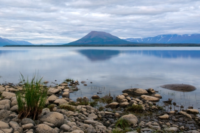
This lake is located at the foot of the Byrranga mountains. From Lake Taimyr flows the river Nizhnyaya Taimyr, which flows into the Kara Sea, and feeds the lake with water from the Upper Taimyr, which carries its waters to the lake.
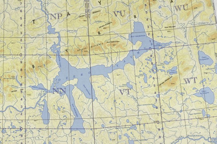
Taimyr Lake Map (click to enlarge)

Where is Lake Taimyr located? See the map above.
Lake Taimyr can be called a record-breaking lake, since it is the only lake on our planet, which occupies the northernmost position far beyond the Arctic Circle.

The lake basin of this lake was formed as a result of glacier activity, so the maximum depth of the lake does not exceed 26 meters.
The northern part of the lake is located in the permafrost zone, so the reservoir has been covered with a thick two-meter layer of ice for more than nine months. Over such a long period, more than eighty percent of the lake's water surface freezes to the very bottom. Less than three months the lake is free of ice cover, but this period cannot be called favorable. At this time, storms and hurricane winds are raging over the lake. The northern shores of the lake are composed of rocks that are easily eroded. Therefore, in this part of the lake, landslides often occur.
Lake Taimyr, like most water bodies in Siberia, is characterized by sharp drops in water level, reaching up to seven meters in the lake.
The northern position of the lake determines the temperature regime of this territory. The average annual temperature here does not exceed -13 o, and in July the highest temperature is only 12 o. In this region, polar night and polar day are common. Due to the harsh conditions, these places are not inhabited by people, therefore there are no settlements here. The only habitable place once was a meteorological station.
However, some representatives of the animal and plant world have adapted to the harsh conditions here. The waters of the lake are rich in omul, burbot, grayling and vendace; there are Siberian mason goby, muksun, broad and whitefish. Swans, ducks and geese, peregrine falcon and Upland Buzzards have chosen these places. During the short summer, the birds manage to raise offspring, and with the onset of cold weather they fly south.
Only for two and a half months a year - from mid-July to the end of September - the northernmost lake of the planet on the Taimyr Peninsula is freed from the ice captivity.
There are no permanent settlements near the reservoir, only a lonely meteorological station is sheltered, once predicting snowstorms and frosts, and occasionally there are lonely dilapidated houses to shelter travelers and fishermen who come to Taimyr to experience the extreme Arctic and see the magical northern lights.
Geographically, Lake Taimyr is located within the boundaries of the Taimyr Reserve on the northernmost span of the Krasnoyarsk Territory. The nearest large settlements are Norilsk and Dudinka. The small village of Khatanga with an airport on the shores of the bay of the same name is the administrative center of the reserve and one of the main starting points of travel to Taimyr.
Climatic conditions of the lake
The harsh climate of the Arctic has an impact on the entire local nature. Long winters with frequent lingering snowstorms, short cool summers, almost no spring affect all life processes in the vicinity of Lake Taimyr. All living things are trying to develop, give offspring in the shortest possible time of the polar summer.
Average winter temperatures in the vicinity of the reservoir are over 13 degrees below zero, maximum temperatures approaching 40 degrees below zero. In summer, the temperature rises to an average of 12 degrees Celsius.
The water temperature in the lake in winter is a little over 0, in summer - no higher than 8 degrees Celsius. The bottom of the reservoir is located on permafrost, the water level changes significantly at different times of the year. In summer, the volume of water in the lake increases by 75%, correspondingly increasing the area of the stretch to 30-50%. By winter, the water level drops from 6 to 1.5 m above the sea, and the area of the water surface decreases from 4500 sq. km up to 1200 sq. km.
In winter, the lake freezes almost to the bottom, forming an ice layer of 2-3 m. Due to a decrease in the water level in winter, the ice cover is deformed: the process is accompanied by noise and crackling of bursting ice. In summer, strong winds almost constantly blow, sometimes raising a real storm on the lake surface with a wave of 1 m high.

Coastal relief
The outlines of the shores of Lake Taimyr are due to the location of the reservoir in the center of the peninsula on the border between the North Siberian, or Taimyr lowland, and the southern slopes of the Byrranga mountains. The length of the reservoir in the west-east direction is about 190 km, the width without bays is about 15-20 km. The lake fills a small basin, from which cracks in the earth's crust extend, watered by numerous bays and coves, the largest of them are Yuka-Yamu, Baikura-Nehru, Yamu-Baukura and others. There are about 10 islands in the water area of the lake, the largest is Botlin, almost 4 m long. The north-western coast is steep, the mountains with a height of 400-500 m come close to the water, slightly retreating in the area of the Ozhidaniya Bay. Rivers and streams flowing down the mountain spurs form alluvial shoals. The eastern coast is gentle, only to the coast of the Yuka-Yamu Bay there are gentle slopes of low, up to 50-100 m, hills, the steep edge of the Turuza-Molla Peninsula. At the eastern edge of Lake Taimyr, there is a vast delta of the river flowing into the Yama-Nehru Bay. The southern coast is gently sloping, with several terraces, the coast of the Yuka-Yamu Bay is slightly hilly.
Several rivers flow into Lake Taimyr, the largest are the Upper Taimyr and Bikada-Nguoma, which form branched deltas with many branches and islets at the confluence, and also the rivers Severnaya, Zapadnaya, Yamu-Tarida flow into the lake. One water artery flows out of the reservoir (the Gulf of Nestor Kulik) - the Lower Taimyr, which flows into the Kara Sea.
Fauna and flora of the lake and coasts
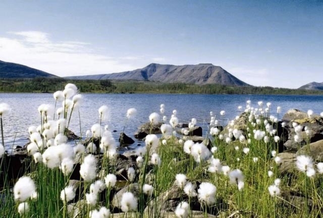
The vicinity of Lake Taimyr is an endless tundra, turning into a forest-tundra at the southern coast. Many believe that in the tundra, except for reindeer, a group of lichens, which is used as the main food in winter by reindeer, nothing grows. With the arrival of summer in June, the open spaces closest to the lake are transformed: cereal and sedge grasses turn green, polar poppies blaze with a scarlet flame, heat shines with orange color, alpine forget-me-nots and bells cover the tundra with a sky-blue carpet, cotton grass whitens with cotton balls. Small clumps of tundra bushes - dwarf birch, polar willow, spruce, northern alder - huddle in bends, sheltered from the wind. In the swampy deltas of the rivers flowing into the lake, whole meadows of berries grow - cloudberries, cranberries, crowberries; upstream in the river valleys, lingonberries, blueberries and blueberries are found in abundance.
Among the representatives of the animal world around the reservoir, the most numerous are reindeer, which migrate seasonally from north to south and vice versa, followed by predators - wolverines, wolves, polar foxes. Sometimes brown bears come to the shores of the lake, lemmings, hares, ermines, foxes live near the southern coast, elk and musk ox rarely appear.
Many birds nest on the lake - sandpipers, geese, various species of ducks, red-throated and white-breasted geese, loons, gulls, wagtails, polar owls and sparrows live in the tundra near the lake, and occasionally a white-tailed eagle is seen in the sky.

Fishing and extreme tourism
Lake Taimyr is rich in fish. Despite belonging to the reserve, fishing in the reservoir is allowed from an inflatable rowboat or from the shore, it is also possible to use motor boats. Usually they fish here using a spinning rod. The catch, as a rule, consists of good specimens of grayling, vendace, burbot, muksun, whitefish, char, perch, taimen, and a small amount of the Siberian subspecies of the sculpin goby.
In addition to fishing enthusiasts, those who want to test themselves in the extreme arctic conditions of the Far North come to Taimyr. Rafting on northern rivers and many kilometers of hiking on the tundra and to the Byrranga mountains is a real adventure for the strong in spirit and physically hardy people. The Taimyr Reserve offers two tours with a visit to the lake - "In the footsteps of Urvantsev" (rafting on the Upper Taimyr) and hiking "Byrranga Mountains".
No less curious are other options for recreation in the vicinity of Lake Taimyr: dog sledding and bird watching, walks to the settlements of the indigenous inhabitants of the Nganasan, Dolgan, Evenki, Nenets peninsula are organized for tourists; national flavor and ethnographic elements of the peoples of the North. In Khatanga, at the Center for the Problems of the North of Russia, the Arctic and Antarctica, daredevils will be offered a trip to the islands of the archipelagos of the Arctic Ocean and in the direction of the North Pole, as well as extreme drift on an ice floe.
Attractions near Lake Taimyr
Most of the tourist routes on the peninsula, including Lake Taimyr, begin in Khatanga from the administrative center of the Taimyr nature reserve. Very often, the weather does not allow going along the route, and tourists see the interesting sights of a small settlement on the shores of the bay of the same name. First of all, the Museum of Mammoth and Musk Ox, which contains a large collection of materials about ancient animals living in the Far North, whose remains are found on the Taimyr Peninsula to this day, arouses curiosity. A visit to the Museum of Permafrost, carved out in a cave, is no less exciting. In winter, under forty-degree frosts in the glacier, it is "warm" - only minus 1 degree. Among the exhibits are 115 mammoth tusks and other curious finds.
The Natural Ethnographic Museum contains materials about the flora and fauna of the Taimyr Peninsula, objects of culture and everyday life of the Dolgans and Nganasans, and in the Literary Museum of Ogduo Aksenova, a Dolgan poetess and the author of the primer, there is an exposition about the life and work of a talented representative of one of the indigenous peoples of Taimyr.

Many are attracted by the Byrranga mountains, translated from the Nganasan - "mountains from which rocky rivers flow down the valleys, where many mosses and lichens grow." One of the oldest and most northern mountain ranges of the planet suffers from severe erosion: being exposed to weathering, exposure to low temperatures, the slopes of the ridges crumble, therefore, in the summer, many rockfalls and landslides occur near the northern shores of Lake Taimyr. The Byrranga Ridge stretches in the submeridian direction from the Yenisei Gulf of the Kara Sea to the Laptev Sea for over 1100 km. The highest point of the peninsula with an indicator of 1146 m above sea level is located in the eastern part of the ridge. The Byrranga Mountains are known for a significant number of glaciers, among which the largest is Unexpected.
Where to stay
During the journey along the route, tourists are accommodated for the night in tents, which they carry with them. The necessary food is also taken on a trip in sufficient quantities - there is nowhere to replenish food supplies in the tundra. On the way of the movement of groups, occasionally there are dilapidated wooden houses, upholstered with roofing felt, in which you can temporarily hide from the wind.
The transfer of groups to the Lake Taimyr area can be carried out from Khatanga by helicopter - an expensive method, but fast and depending on weather conditions, you often have to wait for the blizzard to subside and look for shelter in Khatanga hotels: Zapolyarye, Kotui, Khatanga with price offers from 2500 to 3900 rubles per room.
How to get to Lake Taimyr
Russia, Krasnoyarsk Territory, Taimyr District, Khatanga village
A trip to the lake is quite an expensive undertaking. There are no direct regular flights from Moscow to Khatanga. Eyewitnesses claim that you can fly on a charter plane, which departs 1-2 times a week, depending on the season. The cost of the ticket costs about 30-32 thousand rubles for one passenger.
Flights from Vnukovo and Domodedovo fly to Krasnoyarsk or Norilsk, and from there they fly to Khatanga. The cost of air travel to Norilsk is about 29400-32700 rubles, to Krasnoyarsk - 20400-20800 rubles. A ticket from Krasnoyarsk to Khatanga will cost over 15,000 rubles, from Norilsk - over 12,800 rubles.
You can get to Krasnoyarsk by train; in time, such a journey will last for several days. The price of train tickets ranges from 5,000 to 7,000 rubles in a reserved seat carriage. Then to Khatanga you will have to change to a plane. Flights may be postponed due to bad weather, which will have to wait out in Krasnoyarsk hotels. According to tourists who traveled along this route, the costs are practically the same as by air transport directly to Khatanga.
The transfer of groups from Khatanga to Lake Taimyr is carried out by helicopter. All-terrain vehicles are not used - in the summer the permafrost becomes limp, and deep tracks remain from the tracks, which do not disappear for several years. This is unacceptable in the conditions of the reserve. Hardy and experienced tourists go to the lake on skis or dog sleds in winter, while hiking in the interior of the peninsula in summer takes quite a long time.
There is no exact data on the origin of the word "taimyr". However, there is an assumption that it came from the ancient Tungus "tamur". This word means "rich, dear, valuable."
It is located between the Yenisei and Khatanga bays. There are many lakes on its territory. The largest of them is Lake Taimyr. This reservoir is the second largest after Lake Baikal.
Geographical position
Where is Lake Taimyr located? It is located in the Krasnoyarsk Territory, at the southern foot of the Byrranga mountain range. Is Lake Taimyr wasteful or closed? The river Nizhnaya Taimyr flows out of the reservoir. It carries its waters into which it flows a little to the west. That is why Lake Taimyr is classified as a waste water body. It belongs to the Arctic Ocean basin.

By and large, the lake is considered to be called the Upper Taimyr. The impression is that its waters fell into the earth's fault about one hundred and seventy kilometers long. After passing it, they began to flow further. It's just that the name of the river has changed - Nizhnyaya Taimyr.
This large reservoir, with an area of 4.5 thousand square kilometers, is the northernmost on the planet by its location. Lake Taimyr on the map can be found far beyond the Arctic Circle. Its northernmost point is located near seventy-fifth degrees north latitude.
The origin of the lake
The southern coast of the reservoir has low shores. They are composed of loose sediments. The nature of the banks' layers, as well as the average depth - only three meters (maximum - twenty-six), indicates that Lake Taimyr is of glacial origin.
Climatic conditions
The northern part of the reservoir is located in the tundra zone, where permafrost is widespread. Most of the time, the reservoir is covered with ice. The thickness of the layer reaches two meters, and eighty-five percent of the water area freezes to the very bottom. The lake is free of ice less than eighty days a year. However, this period is characterized by hurricane winds and storms. Due to strong erosion, landslides often occur on the northern shores of the reservoir.

In winter, a large amount of precipitation falls in the area of the lake. However, the snow cover is prevented from forming by the wind and the flat landscape.
During the summer period, the lake is characterized by a strong rise in water. It occurs in connection with the melting of the ice shell. Up to seventy-five percent volume loss occurs during cold seasons. The water level drops on Lake Taimyr can reach seven meters. This is facilitated by the flat relief of the southern area. The same phenomena occurred during the Ice Age.
During the year, the average air temperature in the lake area does not rise above minus thirteen degrees. The warmest is July. In this summer month, the air temperature rises to twelve degrees Celsius. The territory where the lake is located is characterized by polar summers and also polar winters.
Population of the territories adjacent to the lake
The places where the largest northern reservoir is located are not inhabited by people. There are no settlements on Lake Taimyr. There used to be a meteorological station in this area.
Flora and fauna
Despite the fact that the lake is located in an area with a harsh climate, twenty different species of fish are found in it. The most common are muksun, chir and whitefish. There are omul, burbot, grayling and vendace in the reservoir. There are very few Siberian mason bulls.
Geese, swans, ducks live on Lake Taimyr. The peregrine falcon and Upland Buzzards live in those parts. In winter, the birds fly away. They migrate to warmer regions. However, in the summer they certainly return and reproduce offspring.

An interesting fact is that there is no higher aquatic vegetation on the lake. And this is despite the fact that there are individuals that belong to the marine and Baikal water complex. Arctic fish are found in the reservoir - muksun, whitefish, char, etc.
There is no higher aquatic flora in the lake. In this regard, the food chain of the fauna is based on phytoplankton.
During the winter season, the amount of oxygen dissolved in water decreases sharply. This is due to the fact that in the summer, a large mass of organic matter gets into the reservoir. Their decomposition makes the deepest basin inaccessible to fish.
The polar winter and polar summer make their own adjustments to the flora and fauna of the region. Plants develop faster due to the short warm period. The nesting period is accelerating. Chicks appear much faster than in others. In a short period of the polar summer, all living things strive to go through all the stages of their development.
Scientific research of the animal world
The fauna, the habitat of which is Lake Taimyr, was studied for adaptation to the waters of Siberian reservoirs, the level of which also sharply changes throughout the year. The studied representatives of fauna and flora belong mainly to the marine aquatic complex of living organisms. There are some species characteristic of Lake Baikal.
Representatives of marine flora and fauna appeared in the lake due to its communication with the sea through the Lower Taimyr River. The finding of these species is also explained by changes in the levels of the world's oceans in different historical periods.

Representatives of the Baikal ecosystem got into the lake thanks to the ice ages, when the hydrological regime of the entire region changed and large lakes were formed.
Holidays in an exotic location
Lake Taimyr is one of the few territories that has not been negatively affected by human activities. This is a great place not only for summer but also for winter holidays. Pleasing not only with beautiful natural landscapes, but also clear water and clean air.
Lake Taimyr is a fabulous resting place. Not far from the Byrranga mountain range with magnificent gorges and slopes littered with huge boulders, there are cozy country houses. Any vacationer can stay in hotel rooms or at a tourist base. The conditions for rest will be quite comfortable.
It is unusually beautiful on Lake Taimyr in summer. During this period, the sun shines around the clock. Everyone on the shore of the reservoir will feel great. Vacationers can ride bicycles and ATVs, play paintball, billiards, tennis, football and volleyball.
In winter, skiing, tobogganing and snowmobiling will enrich your holiday. It will bring a lot of positive emotions and help you to spend your vacation in a fun and healthy way.
Hunting and fishing
For those who are fond of fishing and love to hunt, Lake Taimyr will be one of the best places for outdoor recreation. This is a real treasure for vacationers. Despite the shallow depth of the reservoir, it is a wonderful place for fishing. Simple amateurs and experienced fishermen will take their souls away, staying with a fishing rod on its shore. Lake Taimyr is teeming with fish. You can also use a boat. Fishing on the lake will be successful with both simple fishing rods and professional tackle. The latter can be rented.

Active hunting is also incomparable in the lakeside area. It can be carried out on wild boar, seal, wolverine, beaver or Siberian roe deer.
Lake Taimyr is the northernmost real large lake in the world. It lies far beyond the Arctic Circle, at the foot of the Byrranga mountains. The extreme northern point of the lake is located at 76 degrees north latitude. The lake is stretched from west to east for 170 kilometers.
In fact, Lake Taimyr is a greatly expanded section of the Upper Taimyr River. In time immemorial, the river ran for itself from west to east, but fell into a large deflection of the earth's crust and gradually filled it to the brim. The water began to look for a way out and ran further east, to the sources of the Novaya River, simultaneously filling the basins of the Kugasalakh and Portnyagin lakes with water. And I made my way to the exit to the Khatanga Bay.

At this time, the Byrranga mountains were covered with an ice sheet. But as soon as the ancient glacier began to melt, a tectonic rift opened across the Byrranga mountains. The height of the bottom of this crack was much lower than the height of the watershed between the basins of the Upper Taimyr and Novaya rivers. Water from the lake quickly slid down a tectonic crack into the Kara Sea, forming the Lower Taimyr River. But the depth of the crack was not so great as to lower the entire lake into the sea. So it remained a blue spot on the map of Eastern Siberia.
And even earlier, when the ocean level was higher, the waves of the sea bay splashed in the place of the lake. This is evidenced by the numerous representatives of the microflora and microfauna of the lake, among which there are many typical marine species. Now the water level is regulated by Nizhnyaya Taimyra, which flows out of the lake along a crack in the Byrranga mountains. When the water rises in the lake, the runoff increases and the river turns into a frantic stream, rushing rapidly between the steep cliffs of the Byrranga mountains, squeezing the river on both sides.
The northern coast, especially in its western part, is rocky outcrops up to 100 meters above the lake level. Frost and ice break rocks into stones, which from time to time crumbling into the water. In the summertime, melt water seeps back into the microscopic cracks in rocks, and then freezes there. When the water freezes, it expands, and again a new block is gradually separated from the monolith of the rock, which after a few years will collapse into the lake.

The climate in the vicinity of the lake is warmer than in the surrounding tundra areas. Compared to Dickson Island, July temperatures are two degrees higher here. In summer, it is here until 21-25 C. The sun does not descend from the firmament all day. It whirls and whirls, illuminating the basin of the lake from both the south and the north because of the rounded peaks of the Byrranga ridge. Summer on the lake is the busiest time of the year. You almost physically feel the sun's rays pouring onto the earth. Combining with the cold peaty mud of the tundra and the transparent cold air, they create a diverse and amazing life.
Before the leaves had time to bloom from the buds, the polar plants are already beginning to bloom: dryads, astragalus, starlets, saxifrage. Sedges turn green. The greenery of the cotton grass soon closes with large white balls of ripe inflorescences that vaguely resemble our dandelions. Horsetails raise their Christmas trees above the brown ground. And above all this, on calm days, a haze of warm air sways, streaming into the cold-bluish sky and taking away the aromas of flowers.
The polar summer is almost synonymous with the polar day. The sun is shining around the clock. Because of this, plants and animals accelerate development and growth. The timing of egg-laying is shortened, chicks are born faster. Everyone is in a hurry, the polar summer is short. The absence of pathogens in the tundra makes warm-blooded organisms more resistant to low temperatures. The abundance of ultraviolet rays, on the one hand, increases the physiological tone of the body, and on the other hand, cleans the air, water, soil from microorganisms. A person in the summer tundra feels better than in the usual central zone of Russia. There are a lot of birds on Lake Taimyr and in the surrounding tundra: swans, geese, ducks, Upland buzzards, peregrine falcons and others. Although they all winter in warm countries, they return here to reproduce offspring. Here in the summer there is much more food and few people ...
Winter starts early on the lake. It is shallow. Only in the central part there is a small basin with a depth of 20 m, and the main area has a depth of less than five meters. The body of water quickly cools down and ice becomes early. The water level continues to drop. After all, only in spring the lake is filled with water, and in the rest of the year the Lower Taimyr takes out more water than other rivers bring. The lake loses up to 75% of the water until next spring. The lake is generally shallow.
The researcher Urvantsev came to the conclusion that from 1854 to 1930 the lake became shallow by 1 meter. Another 400-500 years will pass, and it will be gone. The Verkhne-Nizhnyaya Taimyr river with several tributaries will flow at this place. Ice builds up in the lake throughout the winter until May and reaches a thickness of two meters. Simultaneously with its growth, the water decreases its level and the ice falls to the bottom. In winter, such ice deflections are accompanied by a roar and crackle. About 80% of the entire lake area freezes to the bottom. In winter, the amount of oxygen dissolved in water decreases. The waters of the deepest basin of the lake become inaccessible to fish, since during the summer a lot of organic matter is carried away here, which, by decaying, take all the oxygen from the water.
A unique phenomenon for Lake Taimyr is the absence of higher aquatic vegetation. The lake contains representatives of the marine aquatic complex of living organisms and the Baikal complex. The appearance of the first is explained by the flooding of the lake basin by the waters of the seas, and the origin of the second is difficult to explain. Apparently, the organisms came here from the Yenisei at a time when the hydrography of this region was completely different. For example, when the glacier propped up the waters of the Pyasina and Yenisei, they merged into a single huge lake. From him, memory remained in the form of invertebrates of the Baikal fauna complex.
The lake is quite rich in fish. Among the fish, the most numerous are muksun, whitefish, and broad. They are followed by the number of burbot, vendace, grayling, omul; there are very few Siberian sculpting goby. In 1983 the lake became part of the Taimyr nature reserve. Designing, organizing and forming protected areas is a very difficult undertaking. There were various proposals for the Taimyr Reserve: from two hundred thousand to ten million hectares. In the end, they came to the conclusion that the Taimyr reserve should be organized on an area of 1,348,316 hectares, but in four different areas. In fact, four reserves were organized under the same name. For a person, this may not really matter, but for nature ...
After all, natural complexes in disparate areas cannot live one life. And the duration of their existence will be much shorter than the duration of the existence of natural complexes in a single large protected area.
Cape Sablera 
Geography:
Lake Taimyr occupies a border position among the physical-geographical, botanical, geomorphological and tectonic regions of the Taimyr Peninsula. This is one of the largest freshwater bodies of water in the Arctic. Its drainage basin is located within the Byrranga mountains and the North Siberian (Taimyr) lowland, formed by a thick stratum of Quaternary sandy-clayey deposits and characterized by a hilly, gently rolling relief. The soils in the catchment are tundra, arctic, lying on permafrost. The lake was formed only in the second half of the late Neopleistocene. The basin of Lake Taimyr owes its origin to the currently active structure of the pre-Taimyr trench separating the mountains and lowlands, and to the north-northwest-striking faults separating the Eastern and Central Taimyr. Thus, among the main factors that influenced the formation of its lacustrine basin, one can note the influence of the development of the newest tectonic structures of the east-north-east and north-north-west strikes, as well as the processes of Quaternary sedimentation during the period of sea level stabilization against the background of regression in the Karginsky time. ... V.N. Grese on the basis of hydrobiological data in 1957. The lake is located in the center of the Taimyr Peninsula in a vast shallow basin near the southern slopes of the Byrranga mountains at an altitude of 5 m above sea level. The lake itself is a large freshwater reservoir, stretched out in the latitudinal direction. Its length in latitude reaches 180-190 km. The width of the lake without bays is 15-20 km. In the west, it ends with the shallow bay Ledyanaya, in the east - with the Yamu-Nera bay. From the lake itself, in the form of elongated tongues, there are a number of bays and bays, which were formed as a result of the opening of cracks in the earth's crust due to gravitational tectogenesis, i.e. the effect of cracking in the process of tectonic uplift of the Byrranga mountains. The most significant of them are the bays of Baikura-Nehru, Yuka-Yamu, Yamu-Baukura, etc. There are up to 10 islands in the lake. The largest of which is about. Botlin up to 3-4 km. From the northwest of the mountain ridge. Byrranga with a height of 400-500 m come close to the reservoir and in some places descend to the water with cliffs. In the area of the Bay of Ozhidaniya, the mountains recede somewhat and only in some places approach the coastal zone in separate spurs. Further to the east, the shores of the lake become more gentle. Only in the area of the Yuka-Yamu Bay, the hilly plain adjacent to the lake has individual elevations up to 50-100 m with gentle slopes. The Turuza Molla Peninsula, located in this area, is elevated more significantly above the surrounding terrain; its steep slopes form steep banks. In some areas of the northern and western shores of the lake, 2 terraces protrude noticeably at an altitude of about 15-20 and 8-10 m. Surf banks stretch along the northern coast at a height of 1.5-2.0 m. Along the water's edge in this area there are peculiar beaches 10-12 m wide, made of rounded pebbles with inclusions of separate large and small fragments of rocks. Small streams and rivers flow down from the slopes of the mountains, forming shallows of deposited soil particles at the places where they flow into the lake. A rather developed delta of the river flowing into it juts out into the eastern end of the lake, into the Yama-Nehru Bay. The southern coast of the lake is a slightly hilly tundra. The shores here are composed of soft, easily eroded rocks, in many places they are raised and descend to the water by cliffs reaching 25-35 m in height. Fossil ice lenses are often found in the cliff sections.
Upper Taimyr river 
Landslides are sometimes observed along the shores of the lake. In the southern part, only the shores of Yuka-Yamu Bay rise noticeably above the surrounding terrain. Three terraces are marked on the entire southern coast of Lake Taimyr: the first, floodplain, 2-4 m high; the second at a height of 8-10 m; the third is up to 25-30 m above the water line. On these terraces there are many small lakes, usually giving rise to numerous rivers and streams flowing into Lake Taimyr.
The largest river flowing into the lake, r. Upper Taimyr, originates on the southern slopes of the ridge. Byrranga. In the middle course, relatively large tributaries of the rr flow into it. Luktah, Gorbit and B. Logat. The length of the river. Upper Taimyr is about 480 km, and the catchment area is 50 220 sq. km. When it flows into the lake, the river forms a fairly developed delta with many islands, shoals and shallow channels. The river B. Logata, making up about 30% of the total runoff of the river. V. Taimyr, carries about the same amount of sediment as the rest of the V. Taimyr river.
Perhaps this is due to the fact that the catchment of the river. B. Logata is completely located within the Taimyr lowland, and most of the rest of the catchment of the river. V. Taimyr - in the Byrranga mountains, and, therefore, most of the sediment from the mountains accumulates in the alluvial cones of mountain rivers, which they form when they exit to the plain and in such sedimentary traps as, for example, Lake. Levinson-Lessinga, Shchel, etc. Thus, most of the sediment entering the lake. Taimyr with the waters of the r. V. Taimyr, is formed in the flat part of the catchment area. The second largest river flowing into the lake in its eastern part is the r. Bikada, originating also on the southern slopes of the ridge. Byrranga, but northeast of the lake.
This river, when it flows into the lake. Taimyr also forms a developed delta with a large number of low-lying islands and many channels, the predominant part of which dries up in summer. In addition to those mentioned, several smaller rivers flow into the lake. One large river, Nizhnaya Taimyr, flows out of the lake (the Gulf of Nestor Kulik), which flows in a northerly direction and flows into the Kara Sea. The lake is nourished mainly by melting snow accumulated during the winter period. Permafrost, widespread throughout the basin, facilitates the rapid implementation of surface runoff from the catchment area in the spring and prevents moisture from seeping into the ground.
Some additional source of food on the Taimyr Peninsula is the melting of fossil ice in the coastal cliffs of rivers and a very insignificant supply of subpermafrost (juvenile) waters to the lake. Lake Taimyr is a huge sedimentation tank, where surface runoff water flowing from the drainage basin leaves almost all the particles carried by them. After settling, sands and silts gradually fill the basin of the lake and form extensive shoals.
The western and southern regions of the lake are especially shallow, where the shores are composed of easily eroded rocks. Therefore, the shoals here are composed mainly of sands and, in some cases, silty sands. In the eastern regions of the lake, pebble-boulder deposits in the form of debris of crumbling shores are most often found. At the bottom of the central basin and deep-water depressions of the lake, deposits of gray silt were found. Along the northern shores, where the strongest currents are noted, the shoals are composed of pebbles, rubble and sand. On the northwestern shores, where bedrocks come close to the water's edge, rubble and pebbles predominate in the shallows, which are talus of crumbling shores.
There is no doubt that the area of the peninsula was once the seabed. Middendorf found sea shells near the Lower Taimyr River, currently living in the Arctic Ocean. The northernmost part of the peninsula is covered with snow almost all year round. Summer here is no longer than 6 weeks, and at this time there are snowstorms. The peninsula is covered with tundra and except for the southern part.
The lake is characterized by a rise in the level from the beginning of summer to August, followed by a decrease until the next spring, during which up to 75% of the water volume is lost. A change in the level during the year leads to a significant - up to 30-50% - change in the area of the mirror, up to 84% of the entire Lake Taimyr freezes to the bottom during each winter, including up to 25% of the permanent water area of the lake. The average annual water level is 6 m, but its seasonal decrease can reach a height of 1.5 m above sea level, and the area of Lake Taimyr can be reduced to 1,200 km².
A shallow depth and a drop in the water level by an average of 5.9 m during the winter period lead to deformation of the ice cover and cracking. The thickness of the ice reaches 2-3 m, the formation of cracks followed by the fall of ice floes is accompanied by strong crackling and noise.

Ecological tourism:
It is planned to start actively developing ecological tourism in Taimyr.
According to a new project for the development of mass tourism, a visit center is planned to be opened in Taimyr, as well as the allocation of tourist areas and zones of limited visits on the territory of reserves.
Among the routes that the authorities intend to actively develop are Lake Taimyr, the Shrenk River, the Putorana plateau, where VIP tours and helicopter excursions are planned, and Dikson, where polar bear and walrus photo hunting can be organized, as well as historical tours.
According to experts, Taimyr will be able to receive more than 80,000 tourists annually.

Lake ecosystem
Arctic fish species are found in Taimyr - whitefish, muksun, char, etc. There are no representatives of higher aquatic flora in the lake, the food chain of aquatic animals is based on phytoplankton. During the winter period, the amount of dissolved oxygen in the water decreases, since in summer a lot of organic matter is carried away here. The decomposition of sediments makes the region of the deepest basin inaccessible to fish.
The fauna of Lake Taimyr was studied for the adaptation of species inhabiting it and the possibility of their migration to Siberian reservoirs, which are also distinguished by significant level changes throughout the year. Basically, the flora and fauna of the marine aquatic complex of living organisms are represented in Taimyr, there are also species characteristic of Lake Baikal. The appearance of the first species is explained by the communication of the lake with the sea through the Lower Taimyr Peninsula and changes in the level of the world ocean in different historical periods. The presence of representatives of the Baikal ecosystem is explained by ice ages, during which the hydrological regime of the region changed greatly with the formation of large glacial lakes in northern Asia.
The Taimyr Islands are a nesting place for migratory birds - red-breasted geese, geese, etc.
Taimyr river basin
The Taimyr River flows through the Taimyr. Above the confluence with the lake, it is called Verkhnyaya Taimyr, and after leaving it - Nizhnyaya Taimyr. Lake Taimyr plays a regulating role in the water regime of the lower reaches of the river.
The lake level begins to rise with the onset of summer and continues to rise until early August. During this period, the outflow of water from the lake through the Lower Taimyr is restrained by ice jams on the river. After cleaning the channel, a rapid decrease in water level occurs, which continues at a slower pace until the next spring. For example, in 1996, the rise in the level of the lake until July 27 was replaced by a rapid drop by 70 cm for the period from July 27 to August 7, which, taking into account the previous inflow of water into the lake, corresponds to an increase in the discharge of the Lower Taimyra by 5,000 - 6,000 m³ / s per day. After such an event, which is repeated every season, the water discharge of the Lower Taimyra gradually decreases along with the fall in the lake level.
Erosion of the Byrranga mountains
Seasonal fluctuations in the water level of Lake Taimyr can reach 7 m, the relief of the southern flat area allows the rise to 50 m above sea level, which took place during the glaciation era. A set of factors such as - the large geological age of the Byrranga ridge; significant seasonal, annual and secular changes in the level of the lake; large changes in air temperature throughout the year - lead to the rapid destruction of the rocks of the northern coast, which have undergone significant erosion and are very often unstable. In the summer, rockfalls and talus are frequent in this area of Taimyr.
Lake Taimyr, mammoth tusk 
JOURNEY TO LAKE TAYMIR
We rise to the high bank to survey the vastness of Lake Taimyr. And here, instead of the expected surface of the water to the horizon, we see huge shoals, cut by small channels and the main stream of water 100 meters wide, going into the distance.
Once again, we check with the GPS navigator. That's right, we are on the lake. It's just that there is no water in it! Here is the second largest lake after Lake Baikal!
Don't trust the cards! They show Taimyr Lake at the time of maximum flooding - in the spring. In summer, it sharply becomes shallow, and its entire southwestern part is a huge sandbank, dissected by channels along which the water of the Upper Taimyr River is distributed.
The eastern, deep-water part of the lake does not change its shape depending on the season. The maximum depth there reaches 26 meters.
The lake is shallowing due to the fact that the Nizhnyaya Taimyr river, flowing out of the lake, continues to develop its channel, deepening it and lowering the level of the lake relative to the Arctic Ocean.
During the research of the expedition of N. N. Urvantsev at the beginning of the 20th century, evidence was found that the level of the lake decreased by a meter during the period 1854-1930.
In addition, the Upper Taimyr River, which carries a lot of sand and silt along with the water, slowly fills the western part of the lake basin with them.
We were again faced with the question of which channel to sail to Cape Sablera.
We decided to sail as close to the western shore of the lake as possible. It soon became clear that low water does not interfere with swimming on the lake, but, on the contrary, helps.
All shoals are open and clearly visible. The depth in the channel along which we sailed was great.
We were lucky with the weather. The wind died down. Gradually, the harsh clouds began to part and we saw the sun.
In bad weather, we would not dare to sail forward. Storms on Lake Taimyr are strong.
Cape Volny 
About 5 - 6 kilometers from Cape Sabler, the channel expanded,
the depth under the keel of our boats was not at all great - it was possible to stand knee-deep in the water.
After another kilometer, the boats began to cling to the bottom. Have sailed! Again, as in the mouth of the Upper Taimyra, we found ourselves at a dead end.
Cape Sabler was visible only four kilometers away, but a sandbank blocked the way to it.
The choice was simple: either go back 10 kilometers and turn there into another channel, or try to find a passage between the shoals.
We went on foot to explore.
The sandbank along which we sailed until we reached a dead end was huge.
After passing half a kilometer back, we saw that there was a passage. We just didn't notice him. All the water in the shallow water imperceptibly went to the indigenous shore of the lake.
In shallow water, the boats were guided and, as soon as the depth increased to half a meter, the motors were turned on.
Soon, Cape Sabler appeared ahead, with residential buildings on the shore.
On the last liters of gasoline, we moor to the shore next to the fishermen's boats.
The fishermen with us pulled out from the net several large char and a couple of muksuns.

We go upstairs to the buildings and see the tusks of mammoths in the grass,
which were found on the shallows of the lake and brought to this place by fishermen. They lie as casually as firewood!
At Cape Sablera there are two strong houses and several outbuildings. Nearby are large fuel tanks.
Here helicopters refuel, which fly further to the North.
The high bank offers excellent views of the lake.
The southern coast of Cape Sabler consists entirely of large grassy hillocks. This is the result of thawing permafrost.
We spent the night in a shed, which stood at some distance from the main buildings.
The change house stood on a sleigh welded from metal pipes. This is a typical construction for the Far North.
On such sleighs, ready-made buildings are delivered to hard-to-reach areas by the deputy on the ice of rivers and along winter roads.
After transportation, the sleds become, in fact, the foundation of the building, protecting it from permafrost.
The next day, having previously bought gasoline of dubious quality at 150 rubles per liter, we sailed from Cape Sabler.
The weather was favorable for us - it was sunny and calm.
At first there was no feeling that we were floating on a large lake. A river about 200 meters wide flowed between the sandbanks.
In the distance, the hilly southern coast of Cape Sabler was clearly visible.
Only after 5 kilometers a wide expanse of water appeared. On the left, Cape Fusa jutted into the lake.
Lake Taimyr, Cape Fusa 
The Fedorov Islands are surrounded by a large sandbank and if you look from above, there will be no resemblance to the map.
The size of the islands increased several times.
This sandbank does not make it possible to swim across the lake to the other, eastern shore.
Between Cape Plosky and the Fedorov Islands, the fairway narrows sharply again. A characteristic feature of Plosky Cape is a rusty all-terrain vehicle on the shore.
The sandy spit stretches from the Fedorov Islands to Cape Farvaterny. The sign of Cape Farvaterny visible from afar is a large gray mountain, the slopes of which are dotted with boulders.
Approaching Cape Farvaterny it seems that the sand spit on the right joins the main bank on the left and there is no further way.
Moreover, just before the cape there is a section of shallow water, through which you can swim only by clinging to the bottom with the keel of the boat. Is it a dead end again ?!
We did not have any information on how to swim on the lake. Several tedious minutes pass and finally a passage opens between the sand spit and the coast, only 50 meters wide!
No wonder the cape is called Farvaterny! 
Immediately behind Cape Farvaterny, a wide expanse of water opened up from coast to coast - the Gulf of Nestor Kulik.
In one place on the shore, we noticed some kind of wooden debris.
The firewood there is of great value, so we moored and went to look. It turned out to be a wooden paddle, some strange detail,
like a large mallet and a plaque on which the word "Expedition" could be made out.
The tree in those areas almost does not rot, so the age of the finds can be very long.
We walked around Botlin Island on the right. After that, a view of the Delmersen Island and the Hoffmann Peninsula opened up.
Here Lake Taimyr ends.
view of the island of Delmersen 
An almost collapsed building and several old wooden barrels for salting fish lay on the shore. Hooray! We'll have a bonfire!
We quickly fried the fish and dined well on it.
They decided to break one barrel and take it with them. But it was not there! Our blunt ax bounced off her like iron,
hitting stones did not help either. Nobody knows how many years this barrel has been lying in the open air. But the wood became stained!
Only a shot from a rifle with a 12-gauge bullet helped knock down one upper steel hoop and break the barrel.
The Lower Taimyr River begins behind the Goffman Peninsula. Thanks to good weather, we sailed Lake Taimyr in just two days.
One day went to the section from the mouth of the Upper Taimyra to Cape Sablera and another day to the section from Cape Sabler to the beginning of the Lower Taimyra.
- a peninsula in Russia, the northernmost mainland of the Eurasian continent, located between the Yenisei Gulf of the Kara Sea and the Khatanga Gulf of the Laptev Sea. By the nature of the surface, it is divided into 3 parts: the North Siberian lowland, the Byrranga mountains (height up to 1125 meters), stretching from the southwest to the northeast, and the coastal plain along the coast of the Kara Sea. The southern border of the peninsula is the northern ledge of the Putorana plateau.
The largest rivers in Taimyr: Pyasina, Upper and Lower Taimyr, Khatanga.
The largest lakes: Taimyr, Portnyagino, Kungasalakh, Labaz, Kokora.
Largest bays:
Middendorf, Pyasinsky, Simsa, Taimyr Bay, Teresa Klavenes, Thaddea, Maria Pronchishcheva Bay.
Administratively it is part of the Krasnoyarsk Territory, forming a special Taimyr District in it. Largest cities: Norilsk, Dudinka.
There are several hypotheses about the origin of the toponym "Taimyr". The most widespread is the version of Evenk origin from the Old Tungus “tamur” (“valuable, expensive, rich”) - this is how the Evenks first called the Taimyr River, which was abundant in fish. In the 19th century, through the geographer and traveler Alexander Fedorovich Middendorf (1815-1894), this name spread to the entire peninsula.
There are also other options, for example. Dolgan "tuoy muora" - "saline lake", in a figurative sense "fertile", since salt is necessary for the life of deer. Or also Dolgan "Tymyr" - "blood vessel".
Nenets "tai myaryi" - "bald", "bald". Perhaps a comparison with the undersized Taimyr tundra.
In the Nganasan language, "taa mire" - "deer paths".
The same word can be parsed into "time" (English - time), and ar (yr) - storing, "frozen in time"
The Taimyr Peninsula is located in the Arctic and Subarctic zones, which determines the extreme severity of the local climate. Taimyr is characterized by long cold winters with temperatures down to -62 ° C and short cool summers. A blizzard is a frequent occurrence, sometimes lasting up to several weeks. Strong winds almost always blow.
Tundra, gley and arctic soils prevail on the territory. The territory of Taimyr belongs to the zone of permanent permafrost. The lowest temperature in Taimyr was observed in Gremyak and Imangda, -62 ° C.
At the extreme northern point of the peninsula - Cape Chelyuskin - the average annual air temperature is −14.5 ° C, the average temperature in January is −28.2 ° C, in July, +1.4 ° C, the absolute minimum temperature is −48.8 ° C.
In Dudinka, the average temperatures are respectively: -9.4 ° C; −26.8 ° C; +13.8 ° C, the absolute minimum temperature is -56.1 degrees.
In Khatanga: -12.4 ° C; −31.5 ° C; + 12.5 ° C, absolute minimum temperature -59 ° C.
The greatest amount of precipitation falls in summer. Northerly winds prevail in summer, south winds prevail in winter.
Many Atlantic cyclones end their lives in Taimyr, due to which this region is often called a cyclone cemetery.
- one of the largest reserves in Russia, located in the north of the Krasnoyarsk Territory, on the Taimyr Peninsula. The Taimyr State Reserve was established on February 23, 1979. The Taimyr nature reserve is of a cluster nature and consists of 4 sections. Area 2 719 688 hectares, including: the main tundra area - 1324042 hectares, the "Ary-Mas" site 15 611 hectares, the "Lukunsky" site - 9 055 hectares, the experimental training ground "Bikada" for the protection of the acclimatized population of musk ox - 937760 hectares and Arctic branch - 433220 hectares, includes 37 018 hectares of the Laptev Sea. The Bikada protected zone and the Arctic branch were added to the reserve in 1994. Prior to this, the “Bikada” protection zone, intended for the protection of the acclimatized population of musk ox in the settlement zone, was a reserve of district subordination; and the Arctic branch was designed as a site of the Great Arctic Reserve. Since March 20, 2013, the Taimyr Reserve has ceased to be an independent institution and became part of the FSBI "Reserves of Taimyr" together with the Putoranskiy and Bolshoi Arctic Reserves.
In 1995, by the decision of MAB UNESCO, the Taimyr Reserve received the status of a biosphere.
The weather here does not become warm: frosts and snow occur even in July. In winter, ice forms on water bodies, about 2 meters thick. The entire territory of the reserve is located in a continuous permafrost zone.
There are many reservoirs on the territory of the reserve, including the rather large Taimyr River with a length of about 570 km and the southwestern part of the large Arctic Lake Taimyr. They diversify the dull tundra landscape and create conditions for the life of aquatic plants and animals.
_______________________________________________________________________________________________
SOURCE OF INFORMATION AND PHOTOS:
Team nomad
http://mik-sazonov.livejournal.com/54841.html
A. Sokolov Chapter 23. Eastern Siberia // Hydrography of the USSR. - 1954
Russian-German Cooperation: The Expedition TAYMYR 1994, Christine Siegert, Dmitry Bolshiyanov et al.
Great Soviet Encyclopedia // B.A. Vvedensky II. - Moscow: PGK named after Molotov, 21.04.1956 - T. 41 // STILTON - TATARTUP //. - S. 524.
Physical and geographical conditions of the Taimyr Reserve, Ministry of Natural Resources of the Russian Federation
N.V. Lovelius CHANGES IN THE LEVEL OF LAKE TAYMIR // Terra Humana (UDC 551.513, BBK 26.30). - 2008 - V. 4. - P. 172-178.
Lake Taimyr, vodzon.com
Taimyr State Reserve, Ecological Center "Ecosystem"
AA Sokolov Chapter 6. Modern glaciation and permafrost // Hydrography of the USSR. - 1954
http://russia.rin.ru/
http://www.abratsev.narod.ru/biblio/sokolov/p1ch23d.html
http://www.photosight.ru
There is no exact data on the origin of the word "taimyr". However, there is an assumption that it came from the ancient Tungus "tamur". This word means "rich, dear, valuable."
The Taimyr Peninsula is located between the Yenisei and Khatanga bays. There are many lakes on its territory. The largest of them is Lake Taimyr. This reservoir is the second largest after Lake Baikal.
Geographical position
Where is Lake Taimyr located? It is located in the Krasnoyarsk Territory, at the southern foot of the Byrranga mountain range. Is Lake Taimyr wasteful or closed? The river Nizhnaya Taimyr flows out of the reservoir. It carries its waters into the Kara Sea, into which it flows a little west of Cape Chelyuskin. That is why Lake Taimyr is classified as a waste water body. It belongs to the Arctic Ocean basin.
 By and large, the lake is considered a part of the river named Upper Taimyr. The impression is that its waters fell into the earth's fault about one hundred and seventy kilometers long. After passing it, they began to flow further. It's just that the name of the river has changed - Nizhnyaya Taimyr.
This large reservoir, with an area of 4.5 thousand square kilometers, is the northernmost on the planet by its location. Lake Taimyr on the map can be found far beyond the Arctic Circle. Its northernmost point is located near seventy-fifth degrees north latitude.
The origin of the lake
The southern coast of the reservoir has low shores. They are composed of loose deposits of the Quaternary period. The nature of the banks' strata, as well as the average depth - only three meters (maximum - twenty-six), indicates that Lake Taimyr is of glacial origin.
Climatic conditions
The northern part of the reservoir is located in the tundra zone, where permafrost is widespread. Most of the time, the reservoir is covered with ice. The thickness of the layer reaches two meters, and eighty-five percent of the water area freezes to the very bottom. The lake is free of ice less than eighty days a year. However, this period is characterized by hurricane winds and storms. Due to strong erosion, landslides often occur on the northern shores of the reservoir. 
In winter, a large amount of precipitation falls in the area of the lake. However, the snow cover is prevented from forming by the wind and the flat landscape.
During the summer period, the lake is characterized by a strong rise in water. It occurs in connection with the melting of the ice shell. Up to seventy-five percent volume loss occurs during cold seasons. The water level drops on Lake Taimyr can reach seven meters. This is facilitated by the flat relief of the southern area. The same phenomena occurred during the Ice Age.
During the year, the average air temperature in the lake area does not rise above minus thirteen degrees. The warmest is July. In this summer month, the air temperature rises to twelve degrees Celsius. The territory where the lake is located is characterized by polar summers and also polar winters.
Population of the territories adjacent to the lake
The places where the largest northern reservoir is located are not inhabited by people. There are no settlements on Lake Taimyr. There used to be a meteorological station in this area.
Flora and fauna
Despite the fact that the lake is located in an area with a harsh climate, twenty different species of fish are found in it. The most common are muksun, chir and whitefish. There are omul, burbot, grayling and vendace in the reservoir. There are very few Siberian mason bulls.
Geese, swans, ducks live on Lake Taimyr. The peregrine falcon and Upland Buzzards live in those parts. In winter, the birds fly away. They migrate to warmer regions. However, in the summer they certainly return and reproduce offspring.
 An interesting fact is that there is no higher aquatic vegetation on the lake. And this is despite the fact that there are individuals that belong to the marine and Baikal water complex. Arctic fish are found in the reservoir - muksun, whitefish, char, etc.
There is no higher aquatic flora in the lake. In this regard, the food chain of the fauna is based on phytoplankton.
During the winter season, the amount of oxygen dissolved in water decreases sharply. This is due to the fact that in the summer, a large mass of organic matter gets into the reservoir. Their decomposition makes the deepest basin inaccessible to fish.
The polar winter and polar summer make their own adjustments to the flora and fauna of the region. Plants develop faster due to the short warm period. The nesting period is accelerating. Chicks appear much faster than in other climatic zones. In a short period of the polar summer, all living things strive to go through all the stages of their development.
Scientific research of the animal world
The fauna, the habitat of which is Lake Taimyr, was studied for adaptation to the waters of Siberian reservoirs, the level of which also sharply changes throughout the year. The studied representatives of fauna and flora belong mainly to the marine aquatic complex of living organisms. There are some species characteristic of Lake Baikal.
Representatives of marine flora and fauna appeared in the lake due to its communication with the sea through the Lower Taimyr River. The finding of these species is also explained by changes in the levels of the world's oceans in different historical periods.
 Representatives of the Baikal ecosystem got into the lake thanks to the ice ages, when the hydrological regime of the entire region changed and large lakes were formed.
Holidays in an exotic location
Lake Taimyr is one of the few territories that has not been negatively affected by human activities. This is a great place not only for summer but also for winter holidays. Pleasing not only with beautiful natural landscapes, but also clear water and clean air.
Lake Taimyr is a fabulous resting place. Not far from the Byrranga mountain range with magnificent gorges and slopes littered with huge boulders, there are cozy country houses. Any vacationer can stay in hotel rooms or at a tourist base. The conditions for rest will be quite comfortable.
It is unusually beautiful on Lake Taimyr in summer. During this period, the sun shines around the clock. Everyone on the shore of the reservoir will feel great. Vacationers can ride bicycles and ATVs, play paintball, billiards, tennis, football and volleyball.
In winter, skiing, tobogganing and snowmobiling will enrich your holiday. It will bring a lot of positive emotions and help you to spend your vacation in a fun and healthy way.
Hunting and fishing
For those who are fond of fishing and love to hunt, Lake Taimyr will be one of the best places for outdoor recreation. This is a real treasure for vacationers. Despite the shallow depth of the reservoir, it is a wonderful place for fishing. Simple amateurs and experienced fishermen will take their souls away, staying with a fishing rod on its shore. Lake Taimyr is teeming with fish. You can also use a boat. Fishing on the lake will be successful with both simple fishing rods and professional tackle. The latter can be rented.
 Active hunting is also incomparable in the lakeside area. It can be carried out on wild boar, seal, wolverine, beaver or Siberian roe deer.