Atmospheric fronts, or simply fronts, are transition zones between two different air masses. The transition zone starts from the surface of the Earth and extends upward to the height where the differences between the air masses are erased (usually to the upper border of the troposphere). The width of the transition zone at the Earth's surface does not exceed 100 km.
In the transition zone - the zone of contact of air masses - there are sharp changes in the values of meteorological parameters (temperature, humidity). There is significant cloudiness, the most precipitation falls, the most intense changes in pressure, wind speed and direction occur.
Depending on the direction of movement of warm and cold air masses located on both sides of the transition zone, fronts are divided into warm and cold. Fronts that change their position little are called sedentary. A special position is occupied by the fronts of occlusion formed when the warm and cold fronts meet. Occlusion fronts can be either cold or warm fronts. On weather maps, fronts are drawn either by colored lines or by symbols (see Fig. 4). Details of each of these fronts will be discussed below.
2.8.1. Warm front
If the front moves in such a way that cold air recedes, giving way to warm air, then such a front is called warm. Warm air, moving forward, not only occupies the space where the cold air used to be, but also rises up along the transition zone. As it rises, it cools down and the water vapor in it condenses. As a result, clouds are formed (Fig. 13).Fig, 13. Warm front in the vertical section and on the weather map.
The figure shows the most typical cloudiness, precipitation and air currents of the warm front. The first sign of a warm front approaching will be the appearance of cirrus clouds (Ci). At the same time, the pressure will begin to drop. After a few hours, cirrus clouds, getting denser, pass into a veil of cirrostratus clouds (Cs). Following the cirrostratus clouds, even denser high-stratus clouds (As) flow, gradually becoming opaque by the moon or the sun. At the same time, the pressure drops more, and the wind, turning slightly to the left, increases. Precipitation can fall from high-layered clouds, especially in winter, when they do not have time to evaporate along the way.
After a while, these clouds turn into stratus (Ns), under which there are usually broken-rain (Frob) and broken-stratus (Frst). Precipitation from stratus clouds falls more intensively, visibility deteriorates, pressure drops rapidly, wind intensifies, and often becomes gusty. When crossing the front, the wind turns sharply to the right, the pressure drop stops or slows down. Precipitation may stop, but usually it only weakens and turns into drizzling. The temperature and humidity of the air are gradually increasing.
Difficulties that can be encountered when crossing a warm front are mainly associated with a long stay in a zone of poor visibility, the width of which ranges from 150 to 200 nm. You need to know that sailing conditions in temperate and northern latitudes when crossing a warm front in the cold half of the year worsen due to the expansion of the zone of poor visibility and possible icing.
2.8.2. Cold front
A cold front is a front moving towards a warm air mass. There are two main types of cold fronts:1) cold fronts of the first kind - slowly moving or decelerating fronts, which are most often observed on the periphery of cyclones or anticyclones;
2) cold fronts of the second kind - fast moving or moving with acceleration, they arise in the inner parts of cyclones and troughs moving at high speed.
Cold front of the first kind. A cold front of the first kind, as has been said, is a slowly moving front. In this case, warm air slowly rises upward along a wedge of cold air that invades under it (Fig. 14).
As a result, above the separation zone, first stratus clouds (Ns) are formed, transforming at some distance from the front line into high-stratus (As) and cirrostratus (Cs) clouds. Precipitation begins to fall at the very front line and continues after it has passed. The width of the zone of frontal precipitation is 60-110 NM. In the warm season, in the front of such a front, favorable conditions are created for the formation of powerful cumulonimbus clouds (Cb), from which heavy rainfalls accompanied by thunderstorms fall.
The pressure just before the front drops sharply and a characteristic "thunderous nose" is formed on the barogram - a sharp peak facing downward. The wind turns towards it just before passing through the front, i.e. makes a turn to the left. After passing the front, the pressure begins to grow, the wind turns sharply to the right. If the front is located in a well-defined hollow, then the wind turn sometimes reaches 180 °; for example, a southerly wind can be replaced by a northerly one. With the passage of the front, a cold snap sets in.

Rice. 14. Cold front of the first kind in the vertical section and on the weather map.
The sailing conditions when crossing a cold front of the first kind will be affected by the deterioration of visibility in the precipitation zone and squally wind.
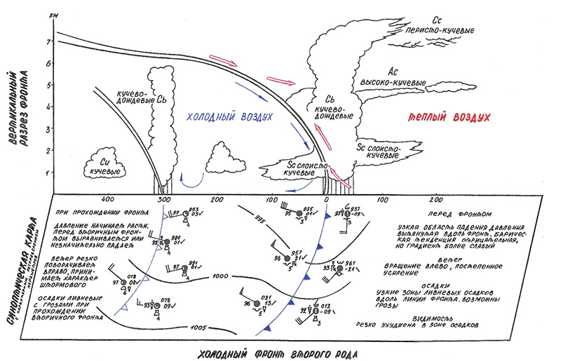
Cold front of the second kind. This is a fast moving front. The rapid movement of cold air leads to a very intense displacement of the prefrontal warm air and, as a consequence, to the powerful development of cumulus clouds (Cu) (Fig. 15).
Cumulonimbus clouds at high altitudes usually extend forward 60 to 70 NM from the front line. This cloud front is seen as cirrostratus (Cs), cirrocumulus (Cc), and lenticular altocumulus (Ac) clouds.
The pressure in front of the approaching front drops, but weakly, the wind turns to the left, a torrential rain falls. After the front has passed, the pressure grows rapidly, the wind turns sharply to the right and significantly increases - it takes on the character of a storm. The air temperature sometimes drops by 10 ° C in 1-2 hours.

Rice. 15. Cold front of the second kind in the vertical section and on the weather map.
The sailing conditions when crossing such a front are unfavorable, since at the very front line, powerful ascending air currents contribute to the formation of a vortex with destructive wind speeds. The width of such a zone can be up to 30 NM.
2.8.3. Sedentary, or stationary, fronts
The front, which does not experience a noticeable displacement either towards the warm or towards the cold air mass, is called stationary. Stationary fronts are usually located in the saddle or in a deep hollow, or at the periphery of the anticyclone. The stationary front cloud system is a cirrostratus, altostratus, and nimbostratus cloud system that looks similar to a warm front. Cumulonimbus clouds often form at the front in summer.The wind direction on such a front hardly changes. The wind speed is lower on the cold air side (Fig. 16). The pressure does not experience significant changes. In a narrow strip (30 NM) heavy rain falls.
On a stationary front, wave disturbances can form (Fig. 17). The waves move rapidly along the stationary front in such a way that the cold air remains to the left - in the direction of isobars, i.e. in a warm air mass. Travel speed reaches 30 knots and more.

Rice. 16. Sedentary front on the weather map.

Rice. 17. Wave disturbances on a slow-moving front.

Rice. 18. Formation of a cyclone on a slow-moving front.
After passing the wave, the front restores its position. An increase in the wave disturbance before the formation of a cyclone is observed, as a rule, if cold air flows from the rear (Fig. 18).
In spring, autumn and especially summer, the passage of waves on a stationary front causes the development of intense thunderstorm activity, accompanied by squalls.
The sailing conditions when crossing the stationary front are complicated due to the deterioration of visibility, and in the summer period - due to increased winds up to stormy ones.
2.8.4. Occlusion fronts
Occlusion fronts are formed as a result of the closing of cold and warm fronts and the displacement of warm air upward. The closing process takes place in cyclones, where a cold front, moving at high speed, overtakes a warm one.Three air masses are involved in the formation of the occlusion front - two cold and one warm. If the cold air mass behind the cold front is warmer than the cold mass ahead of the front, then it, displacing the warm air upwards, will simultaneously flow itself onto the front, colder mass. This front is called warm occlusion (Fig. 19).

Rice. 19. Front of warm occlusion in the vertical section and on the weather map.
If the air mass behind the cold front is colder than the air mass in front of the warm front, then this rear mass will flow under both the warm and the forward cold air mass. This front is called cold occlusion (Fig. 20).
The occlusion fronts go through a number of stages in their development. The most difficult weather conditions at the fronts of occlusion are observed at the initial moment of closing of the thermal and cold fronts. During this period, the cloud system, as seen in Fig. 20 is a combination of warm and cold fronts. Overburden precipitation begins to fall out of stratus and cumulonimbus clouds, in the front zone they turn into torrential ones.
The wind in front of the warm front of the occlusion increases, after its passage it weakens and turns to the right.
Before the cold front of the occlusion, the wind intensifies to a stormy one; after it passes, it weakens and turns sharply to the right. As warm air is displaced into higher layers, the occlusion front gradually erodes, the vertical thickness of the cloud system decreases, and cloudless spaces appear. Stratus cloudiness gradually turns into stratus, altostratus - into altocumulus and cirrostratus - into cirrocumulus. Precipitation stops. The passage of old occlusion fronts is manifested in the accumulation of high-cumulus cloudiness of 7-10 points.

Rice. 20. Front of cold occlusion in the vertical section and on the weather map.
Swimming conditions through the zone of the front of occlusion at the initial stage of development almost do not differ from the conditions of swimming, respectively, when crossing the zone of warm or cold fronts.
Forward
Table of contents
Back
We have considered a warm cyclone front. Now let's turn our attention to the cold front. Let us examine the features and external manifestations that allow yachting to prepare for its approach. Areas of the main front that move towards a relatively warm air mass are called cold. Behind a cold front cold air mass is moving. If the air flow is directed from a cold air mass to a warmer one, then such a front is called cold. The lag of the lower air layers from the upper ones under the influence of friction against the earth's surface leads to the fact that the upper layers fall down and take the form of a rolling shaft. Warm air displaced straight up quickly rises and forms a ridge of dark clouds - cumulonimbus clouds. Depending on the speed of air movement, cold fronts of the first kind (the speed of movement is small) and the second kind are distinguished.
Cold front structure.
The structure of the cold front differs depending on whether it is moving quickly or slowly. For this reason, a distinction is made between:
- a cold front of the first kind - slowly moving, in which clouds and precipitation are located mainly behind the front line, which complicates the detection of its approach in yachting;
- a cold front of the second kind - fast moving, in which cloudiness and precipitation are located mainly in front of the front line.
Cold front of the second kind are observed in the central part of the cyclone, and the first kind - on its periphery.
Cold front of the first kind.
With a cold front of the first kind, the masses of warm air are displaced by a wedge of cold air invading under it. Here, cloudiness is a mirror image of cloudiness. Immediately in front of the cold atmospheric front, cumulonimbus clouds (CL) appear, from which heavy rainfalls, accompanied by thunderstorms, fall. The width of the storm cloud zone is several tens of kilometers.
The Mz-Az cloud system with heavy precipitation is located behind the cold front line. The width of the cloudy zone, its thickness and, accordingly, the width of the precipitation zone is about half that of the warm one. Thus, unlike a warm cloud system of a cold front of the first kind, sailors do not allow sailors to detect its approach in advance by the clouds.
Cold front of the second kind.
A cold front of the second kind is distinguished by the fact that the rapid movement of the air shaft causes a violent rise in front of the front line of the displaced warm air, and the downward movements of air flows prevent the propagation of the cloud system directly behind the front line. The emerging cloud system is mainly a swell of powerful Cb clouds. When they spread in a small amount, Cc, Ac and Sc can form, and under them, in the zone of heavy rainfall, broken cumulus of bad weather is usually observed. At altitudes of 4-5 km, the ascending flow of adiabatically cooled humid air meets the descending flow of adiabatically heated dry air. As a result, an upper secondary front is formed, under which the wall of Cb clouds is pulled forward. Its front edge, which has the character of Az, can gradually divide into ridges of lenticular clouds, Ac. These clouds are carried forward 200 - 300 km and their detection is a reliable warning in yachting about the approach of a cold front of the second kind.
Downward air movements are observed behind the line of the cold atmospheric front in the air mass, especially significant in the front part of the air wedge. Therefore, intramass clouds do not arise here. Soon after passing the cold front line, there is a rapid clearing, up to complete; only after a few hours, when the downward motions die out and the frontal surface rises sufficiently, convective clouds and heavy rainfalls characteristic of an unstable mass can appear.
 Heavy rainfall during the passage of a cold front of the second kind is short-lived (from several minutes to 1 hour), since the width of the precipitation zone is small, and the speed of movement is significant. In the swath of cumulonimbus clouds, gaps or less developed cloudiness of the lower and middle tiers are sometimes found. In some areas, thunderstorm activity develops, which, after decaying in some areas, may appear on neighboring ones.
The wind direction during the passage of cold fronts of both genera changes in the same way as in the case of warm fronts, but the turn to the right (in the northern hemisphere) at the moment of passage is more significant and sharp. At the same time, the wind speed increases sharply.
When the cold front approaches, a short, usually weak, but gradually accelerating pressure drop is observed. Immediately after passing, the pressure begins to rise, due to the replacement of warm air with cold air.
The air temperature after passing the cold front line decreases. The jump in temperature depends on the nature of the changing masses.
Cold fronts of both genera are characterized by prefrontal squalls, especially dangerous for yachting. The air behind the cold front is characterized by a downward movement, which becomes especially intense at the front of the wedge, where friction creates a steep slope of the front surface. The air, falling down, seems to roll forward, like the tracks of a tank, and the speed of its advance in all cases turns out to be greater than the corresponding component of the speed of warm air in the lower layers. The collapse of cold air leads to the displacement of warm air upward and to the emergence of a vortex with a horizontal axis; the phenomena of frontal squalls are connected with this vortex.
 Particularly intense downward movement takes place in the head of cold air. Descending from a height of several kilometers, this air heats up adiabatically, and thanks to this, the temperature jump is smoothed out. In some cases, a secondary cold front arises inside the cold wedge, separating the heated air of the "head" from the air that lies farther and is not captured to such an extent by the downward movement.
This second cold front goes at a distance of several kilometers behind the eroded main one. During its passage, there is a jump in temperature, winds and squalls, but it does not have a cloud system. This phenomenon is called cold front bifurcation. Yachtsmen should keep this in mind and not relax after passing the cold front. Squalls without a visible cloud system can cause many problems in yachting. As they say, he crept up unnoticed.
Secondary cold fronts are usually formed in baric troughs in the rear of the cyclone. They have a cloud system similar to the cloud system of a cold front of the second kind, but the vertical extent of the clouds in them is less than the length of the clouds of the main fronts. In some cases, there may be several troughs and secondary fronts.
Sites of the main front that do not undergo significant movement are called inactive (stationary).
In a cyclone, the cold front moves somewhat faster than the warm one. Over time, they come closer together, and then merge, starting near the center of the cyclone. Such a front, formed as a result of the merger of cold and warm, is called the occlusion front (closed). But about this in.
Watching the weather changes is very exciting. The sun gives way to rain, rain to snow, and gusty winds blow over all this diversity. In childhood, this causes admiration and surprise, in older people - the desire to understand the mechanism of the process. Let's try to understand what shapes the weather and how atmospheric fronts are related to it.
Air mass boundary
In the usual perception, "front" is a military term. This is the line on which the clash of enemy forces occurs. And the concept of atmospheric fronts is the boundaries of contact of two air masses, which are formed over huge areas of the Earth's surface.
By the will of nature, man got the opportunity to live, evolve and populate ever larger territories. The troposphere - the lower part of the Earth's atmosphere - provides us with oxygen and is in constant motion. It all consists of separate air masses, united by a common occurrence and similar indicators. Among the main indicators of these masses, volume, temperature, pressure and humidity are determined. During movement, different masses can come closer and collide. However, they never lose their boundaries and do not mix with each other. - these are areas where sharp weather jumps occur and come into contact.
A bit of history
The concepts of "atmospheric front" and "frontal surface" did not arise by themselves. They were introduced into meteorology by the Norwegian scientist J. Bjerknes. It happened in 1918. Bjerknes proved that atmospheric fronts are the main links in the high and middle layers. However, before the Norwegian's research, back in 1863, Admiral Fitzroy suggested that violent atmospheric processes begin at the meeting points of air masses coming from different directions of the world. But at that moment, the scientific community did not pay attention to these observations.
The Bergen School, of which Bjerknes was a representative, not only carried out their own observations, but also brought together all the knowledge and assumptions expressed by earlier observers and scientists, and presented them in the form of a coherent scientific system.
By definition, an inclined surface that represents the transition area between different air flows is called a frontal surface. But atmospheric fronts are a mapping of frontal surfaces to a meteorological map. Usually, the transitional region of the atmospheric front is tied up at the Earth's surface and rises up to those heights at which the differences between the air masses are blurred. Most often, the threshold of this height is from 9 to 12 km.
Warm front
Atmospheric fronts are different. They depend on the direction of movement of warm and cold massifs. There are three types of fronts: cold, warm, and occlusion formed at the point where different fronts meet. Let's take a closer look at what warm and cold atmospheric fronts are.

A warm front is a movement of air masses in which cold air gives way to warm air. That is, the air of a higher temperature, moving forward, is located in the territory where cold air masses prevailed. In addition, it rises upward along the transition zone. At the same time, the air temperature gradually decreases, due to which condensation of the water vapor in it occurs. This is how clouds form.
The main signs by which a warm atmospheric front can be determined:
- atmospheric pressure drops sharply;
- increases;
- the air temperature rises;
- cirrus, then cirrostratus, and then - high-layered clouds appear;
- the wind turns slightly to the left and becomes stronger;
- clouds become layered rain;
- precipitation of varying intensity falls.
Usually, after the precipitation stops, it gets warmer, but this does not last long, since the cold front moves very quickly and catches up with the warm atmospheric front.
Cold front
Such a feature is observed: the warm front is always inclined towards the direction of motion, and the cold front is always inclined towards the opposite. When the fronts move, cold air wedges into warm air, pushing it up. Cold atmospheric fronts lead to a decrease in temperature and cooling over a large area. As the rising warm air masses cool down, moisture condenses into clouds.

The main signs by which a cold front can be determined:
- before the front, the pressure drops, behind the line of the atmospheric front, it rises sharply;
- cumulus clouds form;
- gusty wind appears, with a sharp change in direction clockwise;
- torrential rain begins with a thunderstorm or hail, the duration of precipitation is about two hours;
- the temperature drops sharply, sometimes by 10 ° С at once;
- there are numerous clearings behind the atmospheric front.
For travelers, going through the cold front is not an easy test. Sometimes it is necessary to overcome whirlwinds and squalls in poor visibility conditions.
Front of occlusions
It has already been said that atmospheric fronts are different, if everything is more or less clear with warm and cold, then the front of occlusions raises a lot of questions. The formation of such effects occurs in the places where the cold and warm fronts meet. Warmer air is then forced upward. The main action takes place in cyclones at the moment when a more impetuous cold front overtakes a warm one. As a result, there is a movement of atmospheric fronts and a collision of three air masses, two cold and one warm.

The main signs by which you can determine the front of occlusions:
- overburden clouds and precipitation;
- abrupt changes without a strong change in speed;
- smooth pressure change;
- lack of sudden temperature changes;
- cyclones.
The front of the occlusions depends on the temperature of the cold air masses in front of it and behind its line. Distinguish between cold and warm occlusion fronts. The most difficult conditions are observed at the moment of the immediate closing of the fronts. As the warm air is displaced, the front erodes and improves.
Cyclone and anticyclone
Since the concept of "cyclone" was used in the description of the front of occlusions, it is necessary to tell what this phenomenon is.
Due to the uneven distribution of air in the surface layers, zones of high and low pressure are formed. High pressure zones are characterized by an excessive amount of air, low pressure - an insufficient amount of it. As a result of the overflow of air between the zones (from excess to insufficient), wind is formed. A cyclone is a low-pressure area that draws in, like a funnel, the missing air and clouds from the zones where they are in excess.

An anticyclone is a high-pressure area that displaces excess air into low-pressure zones. The main characteristic is clear weather, since clouds are also forced out of this zone.
Geographic separation of atmospheric fronts
Depending on the climatic zones over which the atmospheric fronts are formed, they are geographically divided into:
- Arctic, separating cold arctic air masses from moderate ones.
- Polar, located between the temperate and tropical masses.
- Tropical (trade wind), delimiting the tropical and equatorial zones.
Influence of the underlying surface
The physical properties of air masses are influenced by radiation and the appearance of the Earth. Since the nature of such a surface can be different, then the friction against it is uneven. Difficult geographic landforms can deform the front line and change its effects. For example, there are known cases of destruction of atmospheric fronts when transshipping over mountain ranges.

Air masses and atmospheric fronts bring many surprises to forecasters. Comparing and studying the directions of movement of the masses and the whims of cyclones (anticyclones), they draw up graphs and forecasts that people use every day, without even thinking about how much work is behind it.
Special weather phenomena are associated with atmospheric fronts. On the one hand, the transition from one air mass to another is accompanied by a sharp fluctuation in meteorological elements. On the other hand, ascending air movements in the frontal zones lead to the formation of vast cloud systems, from which precipitation falls over large areas, and huge atmospheric waves arising in the air masses on both sides of the front lead to the formation of atmospheric disturbances - large-scale eddies - cyclones and anticyclones.
The peculiarities of the atmospheric circulation are formed in such a way that atmospheric fronts are constantly eroded and re-emerge. Together with them, air masses on both sides of the front are formed, change their properties (transform).
The approach of atmospheric fronts can be traced rather reliably by some signs.
Warm front
If the front moves in such a way that cold air recedes, giving way to warm air, then such a front is called warm.
The angle of inclination of the warm front to the horizontal surface is about 0.5 ◦. There are two air masses vertically in the troposphere. The cold air remains in a narrow wedge at the ground. Warm air rises up the frontal surface. Since the rise at all heights is slow, layered clouds are formed over huge spaces. Warm air, moving forward, not only occupies the space where the cold air used to be, but also rises up along the transition zone. As it rises, the warm air cools, the water vapor in it condenses. As a result, clouds are formed, which are characterized by special cloudiness, precipitation and air currents of a warm front. The first sign of a warm front approaching will be the appearance of cirrus clouds (Ci). At the same time, the pressure will begin to drop. After a few hours, cirrus clouds, getting denser, pass into a veil of cirrostratus clouds (Cs). Following on the cirrostratus clouds flow even denser high-stratus clouds (As), gradually becoming not translucent by the moon or the sun. At the same time, the pressure drops more, and the wind, turning slightly to the left, increases. Precipitation can fall from high-stratus clouds, especially in winter, when they do not have time to evaporate along the way.
After some time, these clouds turn into stratus-rain (Ns), under which there are usually broken-rain (Fr nb) and broken-stratus (St fr). Precipitation from stratus clouds falls more intensively, visibility deteriorates, the pressure drops rapidly, the wind intensifies, and often takes on a gusty character. When crossing the front, the wind turns sharply to the right, the pressure drop stops or slows down. Precipitation may stop, but usually it only weakens and turns into drizzling. The temperature and humidity of the air are gradually increasing.
After the front has passed, the temperature increases, and precipitation stops. In winter, visibility can be poor already due to advective fog in the warm air. Drizzle is possible. In the summertime, visibility behind the front line is improved. Before the warm front, the pressure drops.
Signs that a warm front is approaching are a drop in pressure, an increase in the density and water content of clouds, a decrease in their lower boundary, the appearance of nimbostratus, heavy precipitation, the appearance of scraps of stratus fractus (St, fr) or fractonimbus ().
Difficulties that can be encountered when crossing a warm front are mainly associated with prolonged stay in a zone of poor visibility, the width of which ranges from 150 to 200 miles.
In the cold season, 400 km before the front, precipitation in the form of snow or snow pellets can fall from high-layered clouds. In summer, the precipitation zone narrows to 300 km, since precipitation in the form of light rain or drizzle from As evaporates in warm air, before reaching the underlying surface.
Cold front
When cold air mass replaces warm air, the line along which the frontal surface intersects with the horizontal surface at sea level is called a cold front.
A cold front is a front moving towards a warm air mass. There are two main types of cold fronts:
1) cold fronts of the first kind - slowly moving or decelerating fronts, which are most often observed on the periphery of cyclones or anticyclones;
2) cold fronts of the second kind - fast moving or moving with acceleration, they arise in the inner parts of cyclones and troughs moving at high speed.
On a cold front of the first kind, warm air rises rather slowly up the wedge of cold air. In this case, warm air slowly rises upward along the wedge of cold air invading under it. Above the zone of separation of air masses, first stratus (Ns) clouds are formed, transforming at some distance behind the front into altostratus (As) and cirrostratus (Cs) clouds. Precipitation falls directly on the front line and behind the front. The width of the precipitation zone usually does not exceed 50-120 miles. In summer over the oceans in especially deep cyclones and in winter in the front part of the cold front of the first kind, powerful cumulonimbus (Cb) clouds form, from which heavy rainfalls, accompanied by thunderstorms, fall. The atmospheric pressure in front of the front drops sharply, and behind the front it rises. At the same time, the wind turns to the left ahead of the front and its sharp turn to the right behind the front. The wind changes its direction especially sharply (sometimes by 180 °) when the front is located near the axis of a narrow hollow. With the passage of the front, a cold snap sets in. The sailing conditions when crossing a cold front of the first kind will be affected by the deterioration of visibility in the precipitation zone and squally wind.
On a cold front of the second kind, the rapid movement of cold air leads to the development of intense convective movement of prefrontal warm moist air and, consequently, to the powerful development of cumulus (Cu) and cumulonimbus (CL) clouds.
At high altitudes (near the tropopause), cumulonimbus clouds stretch forward 50–80 miles from the front line. The front part of the cloud system of a cold front of the second kind is observed in the form of cirrostratus (Cs), cirrocumulus (Cc), and lenticular altocumulus (Ac) clouds. Useful and reasonably timely information about the approaching cold front can be obtained using ship radars.
The atmospheric pressure in front of a cold front of the second kind decreases slowly, while behind the front line it increases rapidly. The wind turns to the left, and behind the front it turns sharply to the right and often intensifies to a stormy one. Heavy rain falls in front of the front and at the front, thunderstorms are possible. In the warm season, at some distance from the front (in the cold air mass), the formation of a secondary cold front with rainstorms and thunderstorms is possible.
The sailing conditions when crossing such a front are unfavorable, because at the very front line, powerful ascending air currents contribute to the formation of a vortex with destructive wind speeds. The width of such a zone can be up to 30 miles.
Occlusion fronts
A front consisting of two fronts and formed in such a way that a cold front overlaps a warm or stationary front is called an occlusion front. Complex complex fronts - occlusion fronts are formed by the closing of cold and warm fronts during the occlusion of cyclones. A cold front follows a warm front. The cold front usually moves quickly. Over time, it catches up with the warm one and the fronts close up.
This is a common process in the last stage of cyclone development, when a cold front catches up with a warm one. There are three main types of occlusion fronts due to the relative coolness of the air mass following the initial cold front towards the air ahead of the warm front. These are the fronts of cold, warm and neutral occlusion.
A distinction is made between a warm front of occlusion, if the air behind the cold front is warmer than the air ahead of the warm front, and a cold front of occlusion, when the air behind the cold front is colder than the air ahead of the warm front.
Occlusion fronts go through a number of stages in their development. The most difficult weather conditions at the fronts of occlusions are observed at the initial moment of closing of the warm and cold fronts. During this period, the cloud system is a combination of warm and cold front clouds. Overburden precipitation begins to fall out of stratus and cumulonimbus clouds, in the front zone they turn into torrential ones.
The wind in front of the warm front of the occlusion increases, after passing it weakens and turns to the right.
Before the cold front of the occlusion, the wind intensifies to a stormy one, after passing it weakens and turns sharply to the right. As warm air is displaced into higher layers, the occlusion front gradually erodes, the vertical thickness of the cloud system decreases, and cloudless layers appear. Stratus cloudiness gradually turns into stratus, altostratus - into altocumulus and cirrostratus - into cirrocumulus. Precipitation stops. The passage of old occlusion fronts is manifested in the accumulation of high-cumulus cloudiness of 7-10 points.
The conditions for swimming through the fronts of occlusion at the initial stage of development hardly differ from the conditions for swimming when crossing the warm or cold fronts, respectively.
In their development, the occlusion fronts go through three stages. Particularly difficult weather conditions at the fronts are observed at the moment of closing of the warm and cold fronts. A cloud system is a complex combination of clouds that are characteristic of both warm and cold fronts. Prefrontal overburden precipitation from stratus and cumulonimbus clouds transforms into storm clouds directly in the front zone. The direction and speed of the wind during the passage of the occlusion fronts change in the same way as on simple fronts. Over time, warm air is forced upward and the occlusion front gradually erodes, the vertical thickness of the cloud system decreases, and gaps appear in the cloud cover. At the same time, stratus cloudiness gradually turns into stratus, altostratus - into altocumulus, and cirrostratus, in turn, into cirrocumulus. This restructuring of cloud systems results in an end to precipitation.
The hydrometeorological conditions of navigation in the zones of the fronts of occlusion differ slightly from the conditions of navigation during the passage of simple fronts: cold or warm.
A cloud system is a complex combination of clouds that are characteristic of both warm and cold fronts. The weather conditions during the passage of such fronts are also unfavorable for yachtsmen - they are accompanied by rains with thunderstorms and hail, strong and gusty winds with a sharp change in directions and, at times, poor visibility.
Prefrontal overburden precipitation from stratus and cumulonimbus clouds transforms into storm clouds directly in the front zone. The direction and speed of the wind during the passage of the occlusion fronts change in the same way as on simple fronts. Over time, warm air is forced upward and the occlusion front gradually erodes, the vertical thickness of the cloud system decreases, and gaps appear in the cloud cover. At the same time, stratus cloudiness gradually turns into stratus, altostratus - into altocumulus, and cirrostratus, in turn, into cirrocumulus. This realignment of cloud systems is causing precipitation to end.
Sedentary, or stationary fronts
The front, which does not experience a noticeable displacement either towards the warm or towards the cold air mass, is called stationary.
Stationary fronts are usually located in the saddle, or in a deep hollow or at the periphery of the anticyclone. A stationary front cloud system is a cirrostratus, altostratus, and nimbostratus cloud system that looks something like a warm front. Cumulonimbus clouds often form at the front in summer.
The wind direction on such a front hardly changes. The wind force is less on the cold air side. The pressure does not experience significant changes. Heavy rain falls in a narrow strip (30 miles).
Wave disturbances can form on the stationary front. The waves move rapidly along the stationary front in such a way that the cold air remains to the left, that is, in the direction of isobars in the warm air mass. Travel speed reaches 30 knots or more.
After passing the wave, the front restores its position. An increase in wave disturbance before the formation of a cyclone is observed, as a rule, if cold air flows from the rear.
In spring and autumn, and especially in summer, the passage of waves on a stationary front causes the development of intense thunderstorm activity, accompanied by squalls.
The sailing conditions when crossing the stationary front are complicated due to the deterioration of visibility, and in the summer period - due to increased winds up to stormy ones.
Cold VM weather
Warm weather VM
Warm VM, moving to a cold area, becomes stable (cooling from the cold underlying surface). As the air temperature decreases, it can reach the level of condensation with the formation of haze, fog, low stratus clouds with precipitation in the form of drizzle or small snowflakes.
Flight conditions in a warm VM in winter:
Weak and moderate icing in clouds at subzero temperatures;
Cloudless sky, good visibility at H = 500-1000 m;
Weak bumpiness at H = 500-1000 m.
In the warm season, the conditions for flights are favorable, with the exception of areas with isolated centers of thunderstorms.
When moving to a warmer region, the cold VM heats up from below and becomes unstable VM. Powerful ascending air movements contribute to the formation of cumulonimbus clouds with heavy rainfall and thunderstorms.
Atmospheric front- this is the section between two air masses, differing from one another in physical properties (temperature, pressure, density, humidity, cloudiness, precipitation, wind direction and speed). The fronts are located in two directions - horizontally and vertically
The boundary between air masses along the horizon is called front line the border between the air masses along the vertical - called. frontal zone. The frontal zone is always inclined towards the cold air. Depending on which VM comes - warm or cold, they distinguish warm TF and cold HF fronts.
A characteristic feature of fronts is the presence of the most dangerous (difficult) meteorological conditions for flight. Frontal cloud systems are characterized by significant vertical and horizontal extent. On the fronts, in the warm season, thunderstorms, bumpiness, icing are observed, in the cold season - fogs, snowfall, low clouds.
Warm front- this is a front that moves towards cold air, followed by warming.
 A powerful cloud system is associated with the front, consisting of cirrostratus, highly layered, nimbostratus clouds formed as a result of the rise of warm air along a cold wedge. SMU at TF: low clouds (50-200m), fog ahead of the front, poor visibility in the precipitation zone, icing in clouds and precipitation, ice on the ground.
The flight conditions through the TF are determined by the height of the lower and upper boundaries of the clouds, the degree of stability of the VM, the temperature distribution in the cloud layer, moisture content, terrain, season, and day.
1. As little as possible to be in the zone of negative temperatures;
2. Cross the front perpendicular to its location;
3. Choose a flight profile in the zone of positive temperatures, i.e. below the 0 ° isotherm, and if the temperatures are negative in the entire zone, the flight should be performed where the temperature is below -10 °. During the flight from 0 ° to -10 °, the most intense icing is observed.
When meeting with dangerous MU (thunderstorm, hail, heavy icing, strong turbulence), you must return to the departure airport or land at an alternate airfield.
-Cold front - this is a section of the main front moving towards high temperatures, followed by a cooling. There are two types of cold fronts:
-Cold front of the first kind (HF-1r) Is a front moving at a speed of 20-30 km / h. Cold air, flowing in a wedge under the warm air, displaces it upward, forming cumulonimbus clouds, heavy rainfalls, and thunderstorms ahead of the front. Part of the TV flows onto the XB wedge, forming layered clouds behind the front, overlying precipitation. There is strong turbulence in front of the front, and poor visibility behind the front. The flight conditions through the HF -1r are similar to the conditions for crossing the TF.

When crossing the HF -1r one can find a weak and moderate bumpiness, where warm air is displaced by cold air. Flying at low altitudes can be difficult due to low clouds and poor visibility in the precipitation zone.
Cold front of the second kind (HF - 2p) - it is a fast moving front with a speed of = 30 - 70 km / h. Cold air quickly leaks under the warm air, displacing it vertically upward, forming vertically developed cumulonimbus clouds, heavy rainfall, thunderstorms, squalls ahead of the front. Crossing the HF - of the 2nd kind is prohibited due to strong turbulence, a flurry of thunderstorm activity, strong development of clouds along the vertical - 10 - 12 km. The width of the front at the ground ranges from tens to hundreds of kilometers. After the front has passed, the pressure increases.
Under the influence of downdrafts, a clearing occurs in the front strip after its passage. Subsequently, the CW, falling on the warm underlying surface, becomes unstable, forming cumulus, powerfully cumulus, cumulonimbus clouds with showers, thunderstorms, squalls, strong turbulence, wind shear, and secondary fronts are formed.

Secondary fronts - these are fronts that form inside one VM and separate areas with warmer and colder air. The flight conditions in them are the same as on the main fronts, but meteorological phenomena are less pronounced than on the main fronts, but even here you can find low cloudiness, poor visibility due to precipitation (snowstorms in winter). Secondary fronts are associated with thunderstorms, heavy rainfall, squalls, and wind shear.
Stationary fronts - these are the fronts that remain motionless for some time and are located parallel to the isobars. The cloud system is similar to TF clouds, but with a small horizontal and vertical extent. Fogs, ice, icing may occur in the front zone.
Upper fronts - this is the state where the front surface does not reach the ground surface. This happens if a strongly cooled layer of air is encountered on the path of the front, or the front is blurred in the surface layer, and difficult weather conditions (jet, turbulence) still persist at altitudes.
Occlusion fronts are formed as a result of the closing of cold and warm fronts. When the fronts are closed, their cloud systems are closed. The process of closure of TF and CP begins in the center of the cyclone, where the CP, moving at a higher speed, overtakes the TF, gradually spreading to the periphery of the cyclone. Three VMs are involved in the formation of the front: - two cold and one warm. If the air behind the HF is less cold than in front of the FF, then when the fronts are closed, a complex front is formed, called WARM FRONT OF OCCLUSION.

If the air mass behind the front is colder than the front, then the rear part of the air will leak under the front, warmer one. Such a complex front is called A COLD FRONT OF OCCLUSION.

The weather conditions at the fronts of occlusion depend on the same factors as at the main fronts: - the degree of stability of the VM, moisture content, the height of the lower and upper boundaries of clouds, terrain, season, day. At the same time, the weather conditions of cold occlusion in the warm season are similar to those of the HF, and the weather conditions of warm occlusion in the cold season are similar to those of the TF. Under favorable conditions, the fronts of the occlusion can pass into the main fronts - warm occlusion in the TF, cold occlusion in the cold front. The fronts move along with the cyclone, turning counterclockwise.